  |
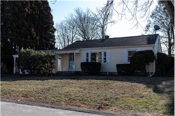
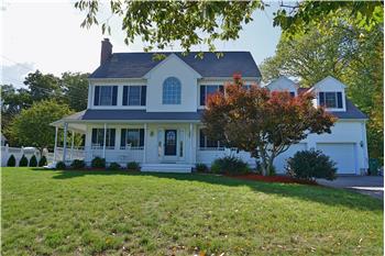
$419,000
Single Family Home 4 Bedrooms 2 Full Bathrooms 1 Half Bathroom 1 Unit Interior: 2,658 sqft Lot: 0.89 acre(s) Year Built: 1998 MLS #: 72076871
|
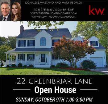
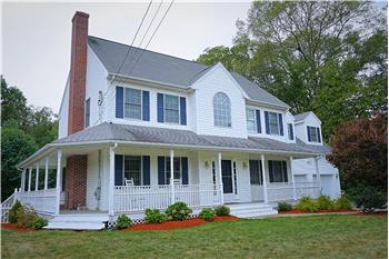
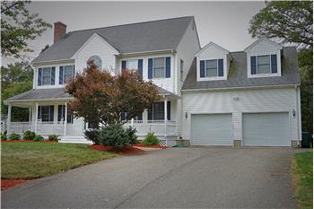
22 Greenbriar Lane
|
Presented by Donald Savastano |

|
Neighborhood Info
|
||||
| [show]Historical population |
|---|
Attleboro is part of the Providence metropolitan area. It is a short distance from Boston, and is linked to the Boston metropolitan area.
As of the 2010 census, there were 43,593 people, 16,884 households, and 11,212 families living in the city; the population density was 1,626.6 people per square mile (628.1/km²). There were 18,022 housing units at an average density of 672.5 per square mile (259.7/km²). The racial makeup of the city was 87.1% White, 3.0% African American, 0.2% Native American, 4.5% Asian (31.5% Cambodian,1.3%Indian, 0.4% Chinese, 0.4% Vietnamese) 0.1% Pacific Islander, 2.8% some other race, and 2.2% from two or more races. Hispanic andLatino people of any race made up 6.3% of the total (2.0% Puerto Rican, 1.7% Guatemalan, 0.5% Mexican, 0.4% Salvadoran, 0.3%Dominican, 0.2% Colombian).[21] Most of the Hispanic and Asian populations were concentrated in the East Side.[citation needed]
Of the 16,884 households, 33.3% had someone under the age of 18 living with them, 50.1% were headed by married couples living together, 11.3% had a female householder with no husband present, 33.6% were non-families, 26.4% were individuals, and 9.8% were people aged 65 or older living alone. The average size of household was 2.55 and the average family size was 3.11.[21]
The age distribution in the city was: 22.7% under 18, 7.9% from 18 to 24, 28.5% from 25 to 44, 28.0% from 45 to 64, and 12.9% over 64. The median age was 39.5 years. For every 100 females there were 95.5 males. For every 100 females aged 18 and over, there were 93.3 males.[21]
For the period 2009–2011, the estimated median annual income for a household in the city was $63,647, and the median income for a family was $71,091. Male full-time workers had a median income of $52,558, females $40,954. Per capita income was $30,039. About 4.2% of families and 6.8% of the population were below the poverty line, including 6.4% of those under 18 and 7.8% of those aged 65 or over.[22]
Education[edit]
Attleboro's school department has five elementary schools (Hill-Roberts, Hyman Fine, A. Irvin Studley, Peter Thacher and Thomas Willett), three middle schools (Brennan, Coelho and Wamsutta), and one high school. Attleboro High School has its own vocational division, and its football team (the "Blue Bombardiers") has a traditional rivalry with North Attleborough High School, whom they play for their Thanksgiving Day football game.Bishop Feehan High School is a co-educational Roman Catholic high school which opened in 1961 and is named for Bishop Daniel Francis Feehan, second Bishop of the Diocese of Fall River. The city also has a satellite branch of Bristol Community College, which used to be housed in the city's former high school building but has since been relocated to an old Texas Instruments site. Bridgewater State University opened a satellite site in Attleboro in 2009, sharing space with Bristol Community College.
Points of interest[edit]

Attleboro has four museums: the Attleboro Arts Museum, the Attleboro Area Industrial Museum,[23] the Women at Work Museum, and the Museum at the Mill. Other places of interest in the city include: Capron Park Zoo;[24] L.G. Balfour Riverwalk, which was once the site of the L.G. Balfour jewelry plant, adjacent to the downtown business district; La Salette Shrine, which has a display of Christmas lights;[25] Triboro Youth Theatre / Triboro Musical Theatre;[26] Attleboro Community Theatre;[27] and Dodgeville Mill.
Revitalization[edit]
In December 2011, the City of Attleboro was awarded $5.4 million in state and federal funding to support revitalization efforts within the city's Historic Downtown area.[28] The city's "Downtown Redevelopment and Revitalization Project"[28] is intended to transform underutilized industrial and commercial parcels into areas of mixed use that include commercial, recreational, and residential space. The project also includes transportation improvements to both MBTA rail and GATRA bus services along with enhanced road construction.[28]
The city project was also selected for the state Brownfield Support Team (BST) Initiative,[28] which encourages collaboration between state, local, and federal government to address complex issues to help pave the way for economic development opportunities in cities and towns across the state of Massachusetts. Contributing BST organizations include theMassachusetts Department of Environmental Protection (MassDEP), MassDevelopment, the Department of Housing and Community Development (DHCD), and the Massachusetts Department of Transportation (MassDOT).[28]
Congressman Jim McGovern highlighted the importance of this project in 2011 by saying, "This transformative funding presents a landmark opportunity for Attleboro to reshape its downtown and make a strong community even stronger. The new transit plan, when implemented, will make Attleboro a model for other small cities, and the aggressive reclaiming of contaminated sites will enhance economic development."[28]
Transportation[edit]
Attleboro is located beside Interstate 95 (which enters the state between Attleboro and Pawtucket, Rhode Island), I-295 (whose northern terminus is near the North Attleborough town line at I-95), US Route 1, and Routes 1A, 118, 123 and 152, the last three of which intersect at Attleboro center. The proposed Interstate 895 was to run through Attleboro and have a junction at the present day I-295/I-95 terminus. When driving from Rhode Island on I-295, the stub exits before the half-cloverleaf exit to I-95.
The city is home to two MBTA commuter rail stations: one in the downtown area and the other in the South Attleboro district, near the Rhode Island border. Attleboro and Taunton are both served by the Greater Attleboro Taunton Regional Transit Authority, or GATRA, which provides bus transit between the two cities and the surrounding regions.
Source: https://en.wikipedia.org/wiki/Attleboro,_Massachusetts