|
|
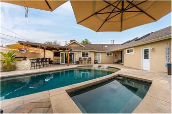
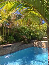
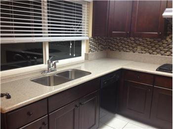
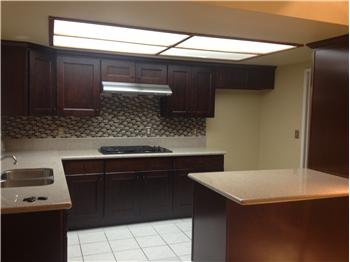
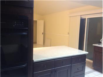
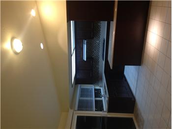
$664,000
Single Family Home 4 Bedrooms 2 Full Bathrooms Interior: 1,655 sqft Lot: 6,000 sqft
|
NEW PRICE - This AD Only - South of Indianapolis
|
Presented by Tami Bowden, CA-BRE#: 01829761 |

|
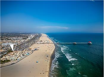
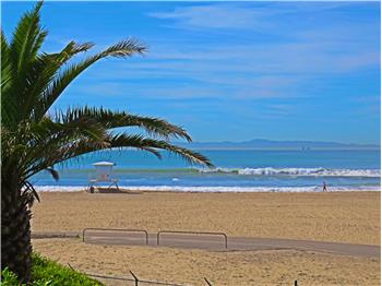
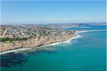
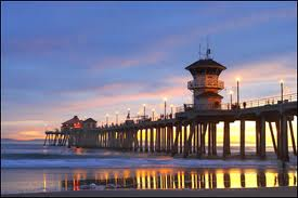
Neighborhood InfoHuntington Beach is a seaside city in Orange County in Southern California. According to the 2010 census, the city population was 189,992; making it the largest beach city in Orange County in terms of population. The estimate for 2012 shows that the population is 189,707.[2] It is bordered by the Pacific Ocean on the southwest, by Seal Beach on the northwest, by Costa Mesa on the east, by Newport Beach on the southeast, by Westminster on the north, and by Fountain Valley on the northeast. Huntington Beach (aka HB) is known for its long 8.5-mile (13.7 km) stretch of sandy beach, mild climate, excellent surfing and beach culture. The ocean waves are enhanced by a natural effect caused by the edge-diffraction of open ocean swells around the island of Catalina. Swells generated predominantly from the North Pacific in Winter and from a combination of Southern Hemisphere storms and hurricanes in the Summer focus on Huntington Beach creating consistent surf all year long thus giving HB the title 'Surf City, USA'.
[edit] History

The area was originally occupied by the Tongva people. European settlement can be traced to a Spanish soldier, Manuel Nieto, who in 1784 received a Spanish land grant of 300,000 acres (1,200 km2), Rancho Los Nietos, as a reward for his military service and to encourage settlement in Alta California. Nieto's western area was reduced in 1790 because of a dispute with the Mission San Gabriel, but he retained thousands of acres stretching from the hills north of Whittier, Fullerton and Brea, south to the Pacific Ocean, and from today's Los Angeles River on the west, to the Santa Ana River on the east. The main thoroughfare of Huntington Beach, Beach Boulevard, was originally a cattle route for the main industry of the Rancho. Since its time as a parcel of the enormous Spanish land grant, Huntington Beach has undergone many incarnations. One time it was known as Shell Beach, the town of Smeltzer, and then Gospel Swamp for the revival meetings that were held in the marshland where the community college Golden West College can currently be found. Later it became known as Fairview and then Pacific City as it developed into a tourist destination. In order to secure access to the Red Car lines that used to criss-cross Los Angeles and ended in Long Beach, Pacific City ceded enormous power to railroad magnate Henry Huntington, and thus became a city whose name has been written into corporate sponsorship, and like much of the history of Southern California, boosterism. Huntington Beach was incorporated on February 17, 1909 during the tenure of its first mayor, Ed Manning. Its original developer was the Huntington Beach Company (formerly the West Coast Land and Water Company), a real-estate development firm owned by Henry Huntington. The Huntington Beach Company is still a major land-owner in the city, and still owns most of the local mineral rights. An interesting hiccup in the settlement of the district occurred when an encyclopedia company gave away free parcels of land, with the purchase of a whole set for $126, in the Huntington Beach area that it had acquired cheaply.[3] The lucky buyers got more than they had bargained for when oil was discovered in the area, and enormous development of the oil reserves followed. Though many of the old wells are empty, and the price of land for housing has pushed many of the rigs off the landscape, oil pumps can still be found to dot the city. Huntington Beach was primarily agricultural in its early years with crops such as celery and sugar beets. Holly Sugar was a major employer with a large processing plant in the city that was later converted to an oil refinery. The city's first high school, Huntington Beach High School, located on Main Street, was built in 1906. The school's team, the Oilers, is named after the city's original natural resource. Meadowlark Airport, a small general aviation airport, existed in Huntington Beach from the 1940s until 1989. [edit] Geography
According to the United States Census Bureau, the city has a total area of 31.9 square miles (82.6 km2). 26.7 sq mi (69 km2) of it is land and 5.1 sq mi (13 km2) of it (16.10%) is water. The entire city of Huntington Beach lies in area codes 657 and 714, except for small parts of Huntington Harbour (along with Sunset Beach, the community adjacent to Huntington Harbour), which is in the 562 Area Code. [edit] ClimateHuntington Beach has a Mediterranean climate (Köppen climate classification Csb). The climate is generally sunny, dry and cool, although evenings can be excessively damp. In the morning and evening, there are often strong breezes, 15 mph (24 km/h). Ocean water temperatures average 55 °F (13 °C) to 65 °F (18 °C). In the summer, temperatures rarely exceed 85 °F (29 °C). In the winter, temperatures rarely fall below 40 °F (4 °C), even on clear nights.[4] There are about 14 inches (360 mm) of rain, almost all in mid-winter. Frost occurs only rarely on the coldest winter nights. The area is annually affected by a marine layer caused by the cool air of the Pacific Ocean meeting the warm air over the land. This results in overcast and foggy conditions in May and June.
[edit] Natural resources
Construction of any kind on the beach is prohibited without a vote of the people, allowing Huntington Beach to retain its natural tie to the ocean rather than having the view obscured by residential and commercial developments. Between Downtown Huntington Beach and Huntington Harbour lies a large marshy wetland, much of which is protected within the Bolsa Chica Ecological Reserve. A $110 million restoration of the wetlands was completed in 2006.[6] The Reserve is popular with bird watchers and photographers. South of Downtown, the Talbert, Brookhurst and Magnolia Marshes, which lie across the street from Huntington State Beach, had restoration completed in 2010.[7] The northern and southern beaches (Bolsa Chica State Beach and Huntington State Beach, respectively) are state parks. Only the central beach (Huntington City Beach) is maintained by the city. Camping and RVs are permitted here, and popular campsites for the Fourth of July and the Surfing Championships must be reserved many months in advance. Bolsa Chica State Beach is actually a sand bar fronting the Bolsa Bay and Bolsa Chica State Ecological Reserve. 
The Orange County run Sunset Marina Park next to Huntington Harbour is part of Anaheim Bay.[8] It is suitable for light craft, and includes a marina, launching ramp, basic services, a picnic area and a few restaurants. The park is in Seal Beach, but is only reachable from Huntington Harbour. The Sunset/Huntington Harbour area is patrolled by the Orange County Sheriff's Harbor Patrol.[9] The harbor entrance for Anaheim Bay is sometimes restricted by the United States Navy, which loads ships with munitions at the Seal Beach Naval Weapons Station to the north of the main channel. [edit] Demographics
[edit] 2010The 2010 United States Census[10] reported that Huntington Beach had a population of 189,992. The population density was 5,959.1 people per square mile (2,300.8/km²). The racial makeup of Huntington Beach was 145,661 (76.7%) White, 1,813 (1.0%) African American, 992 (0.5%) Native American, 21,070 (11.1%) Asian, 635 (0.3%) Pacific Islander, 11,193 (5.9%) from other races, and 8,628 (4.5%) from two or more races. Hispanic or Latino of any race were 32,411 persons (17.1%). Non-Hispanic Whites were 67.2% of the population in 2010,[11] compared to 90.8% in 1970.[12] The Census reported that 189,102 people (99.5% of the population) lived in households, 487 (0.3%) lived in non-institutionalized group quarters, and 403 (0.2%) were institutionalized. There were 74,285 households, out of which 21,922 (29.5%) had children under the age of 18 living in them, 36,729 (49.4%) were opposite-sex married couples living together, 7,685 (10.3%) had a female householder with no husband present, 3,804 (5.1%) had a male householder with no wife present. There were 4,386 (5.9%) unmarried opposite-sex partnerships, and 504 (0.7%) same-sex married couples or partnerships. 18,489 households (24.9%) were made up of individuals and 6,527 (8.8%) had someone living alone who was 65 years of age or older. The average household size was 2.55. There were 48,218 families (64.9% of all households); the average family size was 3.07. The population was spread out with 39,128 people (20.6%) under the age of 18, 15,906 people (8.4%) aged 18 to 24, 54,024 people (28.4%) aged 25 to 44, 53,978 people (28.4%) aged 45 to 64, and 26,956 people (14.2%) who were 65 years of age or older. The median age was 40.2 years. For every 100 females there were 98.5 males. For every 100 females age 18 and over, there were 96.6 males. There were 78,003 housing units at an average density of 2,446.5 per square mile (944.6/km²), of which 44,914 (60.5%) were owner-occupied, and 29,371 (39.5%) were occupied by renters. The homeowner vacancy rate was 1.1%; the rental vacancy rate was 5.4%. 115,470 people (60.8% of the population) lived in owner-occupied housing units and 73,632 people (38.8%) lived in rental housing units. [edit] 2000 |
||||||||||||||||||||||||||||||||||||||||||||||||||||||||||||||||||||||||||||||||||||||||||||||||||||||||||||||||||||||||||||||||||||||||||||||||||||||||||||||||||||||