|
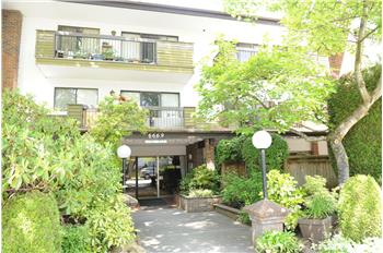
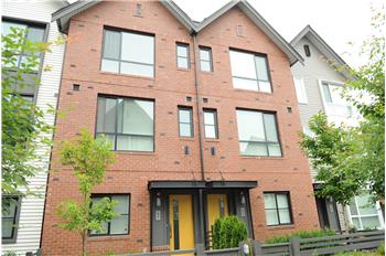
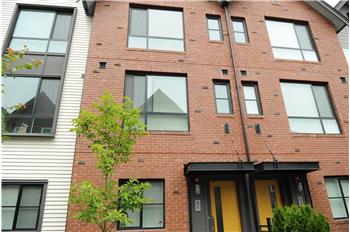
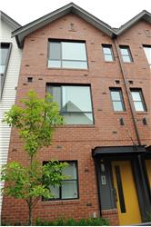
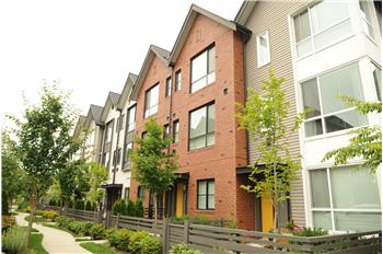
$748,800
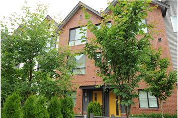
Townhouse 3 Bedrooms 2 Full Bathrooms 1 Half Bathroom 111 Units Interior: 1,305 sqft Year Built: 2016 MLS #: R2279600
|
#51 2380 Ranger Lane
|
Presented by Nazir Abdulla |

|
Neighborhood InfoPort Coquitlam is a city in British Columbia, Canada. Located 27 km (17 mi) east of Vancouver, it is on the north bank of the confluence of the Fraser River and the Pitt River. Coquitlam borders it on the north, the Coquitlam River borders it on the west, and the city of Pitt Meadows lies across the Pitt River. Port Coquitlam is almost entirely bisected by Lougheed Highway. Port Coquitlam is often referred to as "PoCo."[1] It is Canada's 88th-largest city by population. Port Coquitlam is not to be confused with the adjacent and larger Coquitlam. ContentsHistoryThe area was long inhabited by indigenous peoples, most recently by the historic Coast Salish people, including the Kwikwetl'em. The first European settlers began farming beside the Pitt River in 1859. A major impetus to the creation of a municipality was when the Canadian Pacific Railway moved its freight terminus from Vancouver to "Westminster Junction", building a spur line to the Fraser River port of New Westminster in 1911. Port Coquitlam was first incorporated as a municipality on March 7, 1913. Port Coquitlam was originally developed mostly as farmland. Given the expansion and increasing density of Vancouver, it has now been developed for suburban housing, especially in the northern and southwestern areas of the city. The economy is diversified, with a variety of industrial and commercial developments, including metal fabrication, high technology industries, and transportation. DemographicsIn the 2011 Census, Statistics Canada originally reported that Port Coquitlam had a population of 56,342 living in 20,651 of its 21,533 total dwellings, a 6.9% change from its 2006 population of 52,687.[2] Statistics Canada subsequently amended the 2011 census results to a population of 55,958 living in 20,461 of its 21,327 total dwellings, a 6.2% change from 2006.[3] With a land area of 29.17 km2 (11.26 sq mi), it had a population density of 1,918.3/km2 (4,968.5/sq mi) in 2011.[2][3] During the second half of the 1990s, the population grew at a rate of 9.8%, spurred by numerous immigrants. By 2001 they comprised 25% of the population. English was the first language for 76% of the inhabitants. Religions practiced were Catholic 36%, Protestant 32%, Other 14%, and No Religion 18%. In 2009 Port Coquitlam was rated 85th for its murder rate (for Canadian cities with a population over 50K).[4]
LanguagesMother Languages as reported by each person:[11]
TransportationBecause of its primarily suburban nature, Port Coquitlam relies heavily on its vehicular roads to move people and goods. For example, two of its major arterial roads, Shaughnessy Street and Lougheed Highway bisect Port Coquitlam east to west and north to south, respectively. TransLink provides a number of bus routes throughout the city. The most used bus routes in this section of the Greater Vancouver Regional District are the 159, which connects southern Port Coquitlam to SkyTrain at Braid Station. Other bus routes in the city include the 160, which links Port Coquitlam with Vancouver via Coquitlam Central Station and Moody Centre Station, and the 173/174, which runs a loop through the northern half of the city, linking it with regional buses at Coquitlam Central and Port Coquitlam Station. Two major stops in the city include Port Coquitlam Centre and Port Coquitlam Station. The remainder of Port Coquitlam is served by a network of Community Shuttles. The Lougheed Highway passes through Port Coquitlam, running from Coquitlam in the west to the Pitt River Bridge in the east. Although this highway has made much of Port Coquitlam a very congested area, it is one of the few major arterial highways in the area. The Mary Hill Bypass, officially known as Highway 7B, runs adjacent to the Fraser River from the Pitt River Bridge on the east to the Port Mann Bridge on the west. Canadian Pacific Railway has a major rail yard in the central sector of the city. In October 2009 the new Pitt River Bridge, a new seven-lane cable-stayed bridge, opened to the public replacing the existing crossing. The previous crossing was made up of 2 swing bridges, which were removed upon completion of the new bridge. The Pitt River Bridge crosses the Pitt River, connecting Port Coquitlam to neighbouring Pitt Meadows. In March 2010 the Coast Meridian Overpass, a new four-lane cable-stayed bridge, opened to give a new option for traveling north to south over the Canadian Pacific Railway Oxford Street rail yard. A 25 km (16 mi) hiking and biking trail, known as the Traboulay PoCo Trail, completely surrounds the city. Public schoolsPublic schools in Port Coquitlam are part of School District 43 Coquitlam. Secondary schools: Middle schools:
Elementary schools:
The Conseil scolaire francophone de la Colombie-Britannique operates one Francophone primary and secondary school: école des Pionniers-de-Maillardville.[14] Private schools
Notable residents
Surrounding municipalitiesSee also
References
External links
|
|||||||||||||||||||||||||||||||||||||||||||||||||||||||||||||||||||||||||||||||||||||||||||||||||||||||||||||||||||||||||||||||||||||||||||||||||