  |
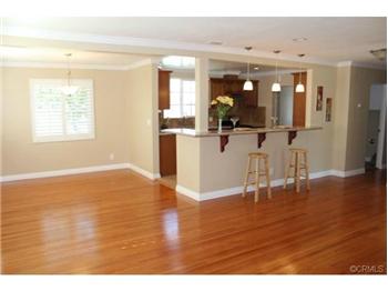
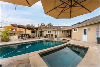
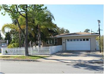
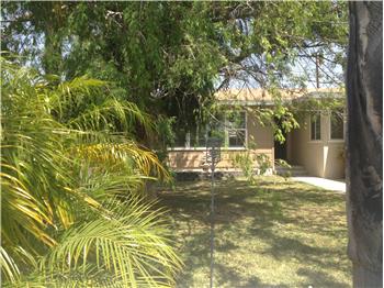
$549,000
Single Family Home 3 Bedrooms 2 Full Bathrooms Interior: 1,389 sqft Lot: 6,960 sqft Year Built: 1955
|
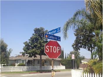
1305 E. Mayfair
|
Presented by Tami Bowden, CA-BRE#: 01829761 |

|
Neighborhood InfoOrange, CaliforniaFrom Wikipedia, the free encyclopedia
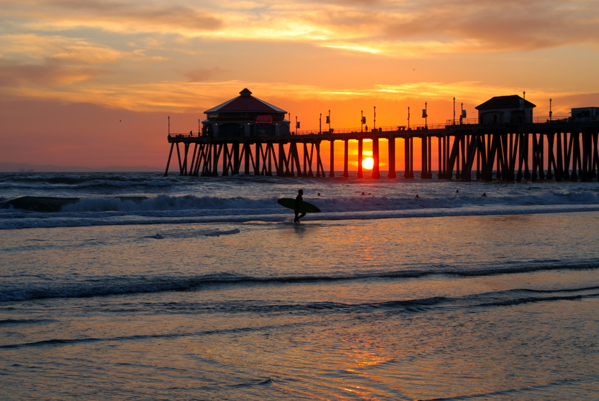
The city of Orange is located in Orange County, California. It is approximately 3 miles (4.8 kilometers) north of the county seat, Santa Ana. Orange is unusual in that many of the homes in its Old Town District were built prior to 1920; whereas many other cities in the region demolished such houses in the 1960s, Orange decided to preserve them. The small affluent city of Villa Park is surrounded by the city of Orange. The population was 136,416 at the 2010 census.
[edit] History
Members of the Tongva and Juaneño/Luiseño ethnic group long inhabited this area. After the 1769 expedition of Gaspar de Portolà, an expedition out of San Blas, Nayarit, Mexico, led by Father Junípero Serra, named the area Vallejo de Santa Ana (Valley of Saint Anne). On November 1, 1776, Mission San Juan Capistrano became the area's first permanent European settlement in Alta California, New Spain. In 1801, the Spanish Empire granted 62,500 acres (253 km2) to José Antonio Yorba, which he named Rancho San Antonio. Yorba's great rancho included the lands where the cities of Olive, Orange, Villa Park, Santa Ana, Tustin, Costa Mesa and Newport Beach stand today. Smaller ranchos evolved from this large rancho, including the Rancho Santiago de Santa Ana. Don Juan Pablo Grijalva, a retired known Spanish soldier and the area's first landowner, was granted permission in 1809 by the Spanish colonial government to establish a rancho in "the place of the Arroyo de Santiago." After the Mexican–American War, Alta California was ceded to the United States by México with the signing of the Treaty of Guadalupe Hidalgo in 1848, and though many Californios lost titles to their lands in the aftermath, Grijalva's descendants retained ownership through marriages to Anglo-Americans. Since at least 1864, Los Angeles attorneys Alfred Chapman and Andrew Glassell together and separately, held about 5,400 acres (22 km2) along both sides of the Santiago Creek (Glassell also had a 4,000-acre (16 km2) parcel where Costa Mesa is today). Water was the key factor for the location of their townsite. Glassell needed a spot he could irrigate, bringing water down from the Santa Ana Canyon and the quality of the soil may have influenced his choice. Originally the community was named Richland, but in 1873 Richland got a new name. In the book, "Orange, The City 'Round The Plaza" by local historian Phil Brigandi, it states, "In 1873 the town had grown large enough to require a post office, so an application was sent to Washington. It was refused, however, as there was (and is) already a Richland, California in Sacramento County. Undaunted, the Richlanders proposed a new name - Orange." The small town was incorporated on April 6, 1871, under the general laws of the state of California. Orange was the only city in Orange County to be planned and built around a plaza, earned it the nickname Plaza City.[3] Orange was the first developed town site to be served by the California Southern Railroad when the nation's second transcontinental rail line reached Orange County.[4] The town experienced its first growth spurt during the last decade of the 19th century (as did many of the surrounding communities), thanks to ever-increasing demands for California-grown citrus fruits, a period some refer to as the "Orange Era." Southern California's real estate "boom" of 1886-1888, fueled by railroad rate wars, also contributed to a marked increase in population. Like most cities in Orange County, agriculture formed the backbone of the local economy, and growth thereafter was slow and steady until the 1950s, when a second real estate boom spurred development. Inspired by the development of a region-wide freeway system which connected Los Angeles' urban center with outlying areas like Orange, large tracts of housing were developed from the 1950s to the early 1970s, and this continues today, albeit at a much slower pace, at the eastern edge of the city. [edit] GeographyThe city has a total area of 25.2 square miles (65 km2), 24.8 square miles (64 km2) of which is land and 0.4 square miles (1.0 km2) of which is water. The total area is 1.75% water. [edit] Climate
Southern California is well known for year-round pleasant weather: The period of April through November is warm to hot and dry with average high temperatures of 74 - 84 °F (29 °C) and lows of 52 - 64 °F (18 °C). Due to the moderating effect of the ocean, temperatures are cooler than more inland areas of Orange County, where temperatures frequently exceed 90 °F (32 °C) and occasionally reach 100 °F (38 °C). The period of November through March is somewhat rainy, as shown in the table to right.[6] The Orange County area is also subject to the phenomena typical of a microclimate. As such, the temperatures can vary as much as 18 °F (10 °C) between inland areas and the coast, with a temperature gradient of over one degree per mile (1.6 km) from the coast inland. California also has a weather phenomenon called "June Gloom or May Gray", which sometimes brings overcast or foggy skies in the morning on the coast, but usually gives way to sunny skies by noon, during late spring and early summer. The Orange County area averages 15 inches (385 mm) of precipitation annually, which mainly occurs during the winter and spring (November thru April) with generally light rain showers, but sometimes as heavy rainfall and thunderstorms. Coastal Torrance receives slightly less rainfall, while the mountains receive slightly more. Snowfall is extremely rare in the city basin, but the mountains within city limits typically receive snowfall every winter. [edit] Cityscape
Old Towne, Orange Historic District, a one square-mile around the original plaza, contains many of the original structures built in the period after the city's incorporation. It is a vibrant commercial district, containing Orange County's oldest operating bank and the oldest operating soda fountain. The Historic District was listed on the National Register of Historic Places in 1997,[7] and is the largest National Register District in California. The Old Towne Preservation Association is a non-profit organization dedicated to maintaining the district. Orange is unique among the region and the state in that it has the second largest concentration of historic buildings.[8] A list of all of the buildings and sites in Orange appears in the National Register of Historic Places.[7][9][10] [edit] Architectural styles in Old Towne Orange
[edit] Demographics[edit] 2010The 2010 United States Census[19] reported that Orange had a population of 136,416. The population density was 5,404.7 people per square mile (2,086.8/km²). The racial makeup of Orange was 91,522 (67.1%) White, 2,227 (1.6%) African American, 993 (0.7%) Native American, 15,350 (11.3%) Asian, 352 (0.3%) Pacific Islander, 20,567 (15.1%) from other races, and 5,405 (4.0%) from two or more races. Hispanic or Latino of any race were 52,014 persons (38.1%). The Census reported that 130,163 people (95.4% of the population) lived in households, 2,587 (1.9%) lived in non-institutionalized group quarters, and 3,666 (2.7%) were institutionalized. There were 43,367 households, out of which 16,303 (37.6%) had children under the age of 18 living in them, 23,572 (54.4%) were opposite-sex married couples living together, 5,260 (12.1%) had a female householder with no husband present, 2,424 (5.6%) had a male householder with no wife present. There were 2,442 (5.6%) unmarried opposite-sex partnerships, and 373 (0.9%) same-sex married couples or partnerships. 8,480 households (19.6%) were made up of individuals and 3,115 (7.2%) had someone living alone who was 65 years of age or older. The average household size was 3.00. There were 31,256 families (72.1% of all households); the average family size was 3.42. The population was spread out with 32,096 people (23.5%) under the age of 18, 16,420 people (12.0%) aged 18 to 24, 39,574 people (29.0%) aged 25 to 44, 33,698 people (24.7%) aged 45 to 64, and 14,628 people (10.7%) who were 65 years of age or older. The median age was 34.8 years. For every 100 females there were 101.5 males. For every 100 females age 18 and over, there were 99.7 males. There were 45,111 housing units at an average density of 1,787.3 per square mile (690.1/km²), of which 26,319 (60.7%) were owner-occupied, and 17,048 (39.3%) were occupied by renters. The homeowner vacancy rate was 1.1%; the rental vacancy rate was 5.1%. 77,179 people (56.6% of the population) lived in owner-occupied housing units and 52,984 people (38.8%) lived in rental housing units. [edit] 2000
As of the census[20] of 2000, there were 128,821 people, 40,930 households, and 30,165 families residing in the city. The population density is 5,506.4 inhabitants per square mile (2,126.5/km²). There were 41,904 housing units at an average density of 1,791.2 per square mile (691.7/km²). The racial makeup of the city is 80.50% White, 0.29 African American, 0.78% Native American, 10.5% Asian, 0.23% Pacific Islander, 6.82% from other races, and none from two or more races. 10.16% of the population are Hispanic or Latino of any race. There are 40,930 households, out of which 37.1% have children under the age of 18 living with them, 57.1% are married couples living together, 11.6% have a female householder with no husband present, and 26.3% are non-families. 19.5% of all households are made up of individuals, and 6.6% have someone living alone who is 65 years of age or older. The average household size is 3.02 and the average family size is 3.43. The population is spread out with 26.7% under the age of 18, 9.9% from 18 to 24, 33.3% from 25 to 44, 20.5% from 45 to 64, and 9.6% who are 65 years of age or older. The median age is 33 years. For every 100 females, there are 100.8 males. For every 100 females age 18 and over, there are 98.7 males. The median income for a household in the city is $58,994, and the median income for a family is $64,573 (these figures had risen to $75,024 and $85,730 respectively as of a 2007 estimate[21]). Males have a median income of $42,144 versus $34,159 for females. The per capita income for the city is $24,294. 10.0% of the population and 6.8% of families are below the poverty line. Out of the total population, 12.5% of those under the age of 18 and 7.5% of those 65 and older are living below the poverty line. [edit] Diversity
North, Central and South Orange, as well the East (Orange Park Acres have differential characters, and after the gentrification of downtown Orange (Glassell St.-Chapman Ave.) in the 1990s, the bulk of the city's socioeconomic and ethnic diversity shifted to the section around The Village at Orange formerly the Mall of Orange until its' renaming in 2003. Orange has a few predominantly Hispanic/Latino neighborhoods, such as the Central Orange (Glassell St.-Katella Ave.) that extend to the Village at Orange, partially unincorporated El Modena (Chapman Ave.-Hewes St.) which the town goes back 125 years,[22] and Olive (Lincoln Ave.-Batavia St.) sections, of Mexican, but also Central American and South American nationalities. Orange has a large Middle-Eastern community in proportion to its population, notably Armenians, Iranians and Arab peoples including Arab-Americans, who have bought homes and own some businesses in the city, and their business strips can be found along Tustin Avenue between Lincoln and Katella avenues facing the Village at Orange. [edit] PoliticsIn the state legislature Orange is located in the 33rd Senate District, represented by Republican Mimi Walters, and in the 60th, 71st, and 72nd Assembly District, represented by Republicans Curt Hagman, Jeff Miller, and Chris Norby, respectively. Federally, Orange is located in California's 40th congressional district, which has a Cook PVI of R +8[23] and is represented by Republican Ed Royce. The current (2013) representatives on the City Council include Mayor Teresa "Tita" Smith, Mayor Pro-Tem Mark Murphy and Councilmembers Fred Whitaker and Mike Alvarez. Orange as part of Orange County is known for its affluence and political conservatism – a 2005 academic study listed Orange among three Orange County cities as being among America's 25 "most conservative," making it one of two counties in the country containing more than one such city (Maricopa County, Arizona also has three cities on the list).[24] 
[edit] Economy[edit] Largest employersAccording to the City's 2011 Comprehensive Annual Financial Report,[25] the top employers in the city are:
[edit] People and culture[edit] Points of interest
Orange is home to parks, lakes, a small zoo, a university, and a wildlife sanctuary. The Outlets at Orange, a large, outdoor shopping and entertainment center, is located on the western edge of the city. It features Old Navy, Hollister, Ann Taylor Factory Store, and Saks Fifth Avenue OFF 5th as well as high quality entertainment venues including AMC Theatres, Dave & Buster's, Vans Skatepark and Lucky Strike Bowling Center. Historically, the plaza has been primarily home to a wide variety of antique shops—and has become a well known destination amongst antique collectors. A more recent trend has brought clothing boutiques, and several casual and upscale restaurants. It also features two Starbucks locations, mirroring each other on opposite ends of the plaza, RadioShack, Wells Fargo bank, a Masonic lodge, and is within walking distance of Chapman University and the newly reconstructed public library. Films such as That Thing You Do starring Tom Hanks, Accepted starring Justin Long, and Big Momma's House were all filmed in the historical Old Town Orange.[26] The Woman's Club of Orange[27] Organized February 1915, is located near the plaza in the Old Towne District. Their clubhouse, built in 1923-1924, is entered in the National Register of Historic Places.[28] In 2009 Woman's Club of Orange, a member of the General Federation of Women's clubs, is still a very active and vibrant club of 180 members. Their annual Flower Show, celebrating its 72nd year in April is a major city event. For over 100 years, during Labor Day Weekend, the plaza plays host to the Orange International Street Fair. Friends, families and neighbors get together to experience a variety of food, music and dance from cultures around the world. The profits from the event go to non-profit charities that help people in the community. The "Villa Park Orchards Association" packing house, located along the former Atchison, Topeka and Santa Fe Railway (now BNSF Railway) mainline, is the sole remaining fruit packing operation in Orange County. The Lewis Ainsworth House is the city's only restored house museum. [edit] Transportation[edit] AutomobileLike most cities in Southern California, the primary means of transportation is the automobile. Orange is situated near many state freeways, as well as Interstate 5, also known as the Santa Ana Freeway. The junction of "the 5" with two state highways (SR 57 "Orange Freeway" and SR 22 "Garden Grove Freeway"), commonly called the "Orange Crush", is one of the busiest interchanges in Orange County, and is located on the southwestern edge of the city. The eastern areas of Orange are served by the Eastern and Foothill Toll Roads, two of California's first toll highways, which connect the city with the cities of Irvine and Rancho Santa Margarita. Most highways do not go through Orange but rather begin or end there. The 55 is born of the 91 in the northeast of the city, while the 22 and the 57 both spring from the southwest. [edit] Rail
The town's first rail service, the Santa Ana, Orange & Tustin Street Railway, was a 4.04-mile (6.5-km) long horsecar line that ran between Santa Ana and Orange, beginning in 1886. One year later, the Santa Ana & Orange Motor Road Company purchased the line, using a steam "dummy" car and a single gasoline motorcar as its means of conveyance. In 1906, Henry E. Huntington acquired the company under the auspices of the Los Angeles Inter-Urban Railway and electrified the line. Passenger service over the new line operated by Huntington's Pacific Electric Railway began on June 8, 1914, originating at the PE's depot on Lemon Street. The route provided freight service to the local citrus growers, in direct competition with the Atchison, Topeka and Santa Fe Railway. Pacific Electric sold out in 1961 to the Southern Pacific Railroad, who ultimately abandoned the line in 1964. The Santa Fe, under its affiliate the Southern California Railway, laid its first tracks through Orange in 1886, and established its first depot the following year. The route would become part of the railroad's famous "Surf Line", and by 1925, sixteen daily passenger trains (the Santa Fe's San Diegan) made stops in Orange. During peak growing seasons, as many as 48 carloads of citrus fruits, olives, and walnuts were shipped daily from the Orange depot as well. Rail connections to Los Angeles, the Inland Empire, and Northern San Diego County are provided by the Metrolink regional commuter rail network. The Orange Metrolink station's platform is situated adjacent to the former Santa Fe depot in the downtown Historic District, which is also home to an Orange County Transportation Authority (OCTA) bus station, is the second busiest station of the entire Metrolink train system due to its position serving as a transfer station for the Orange County and the IEOC Metrolink lines. The former Santa Fe mainline links the cities of Los Angeles, Riverside, and San Diego via a junction north of the station. [edit] AirportsJohn Wayne Airport (SNA) in nearby Santa Ana, California, provides daily scheduled airline service for the area. [edit] Schools, colleges and universities
[edit] Sports
In 1978 and 1979, the California Sunshine was a professional soccer team that played regular season games in Orange. The city roots for major league teams: the Los Angeles Angels of Anaheim of baseball and the Anaheim Ducks of ice hockey, right along the city borders across the Santa Ana River in Anaheim. In the city proper: the Sou Cal A's of the Southern California Collegiate Baseball Association play in Athletic (or Richland) Field. [edit] Notable people
[edit] Sister citiesOrange has five sister cities, as designated by Sister Cities International:
Orange used to have two community partnerships with Utrecht, the Netherlands; and Santiago de Chile, Chile. [edit] See also
[edit] References
[edit] External links
|
||||||||||||||||||||||||||||||||||||||||||||||||||||||||||||||||||||||||||||||||||||||||||||||||||||||||||||||||||||||||||||||||||||||||||||||||||||||||||||||||||||||||||||||||||||||||||||||||||||||||||||||


