  |
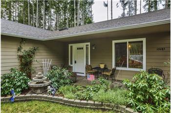
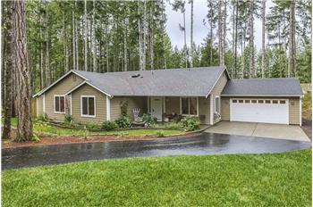
$299,900
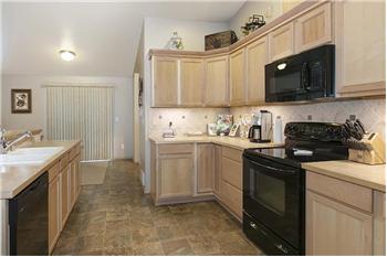
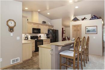
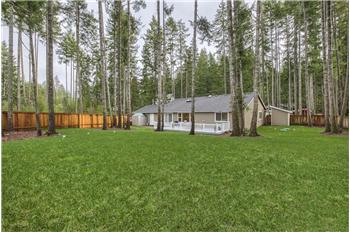
Single Family Home 3 Bedrooms 2 Full Bathrooms 1 Half Bathroom Interior: 2,320 sqft Lot: 20,473 sqft Year Built: 2008
|
12685 Burchard Dr Sw
|
Presented by Stacia Whatley |

|
Neighborhood Info
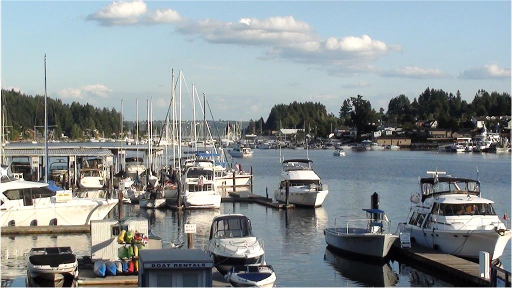
Wye Lake is located in Kitsap County, just past the Pierce County line. It has restrooms and a public boat launch. The parking area is pretty spacey. And if you are lucky, you’ll be greeted by the sweetest residents, 2 puppies that love having visitors. It is open from the last Saturday in April until October 31st. It has state wide rules with minimum of 5. The lake contains bass, catfish, and trout that I have personally caught or seen being landed. The reg book lists bass and all game fish. Bass is limited to 5, size: less than 12" or greater than 17" that may be kept, no more than one over 17"s. But if the lake were to have good bass fishing, please release all or some of your catch so they can grow!!
Power bait seems to be the bait of choice for anglers here, but worms and Rapala lures have done well here, also. Trolling is also another fave choice for anglers that fish here. Fly fishing is good as long as you hit it at the right time of the season, early or late summer. In between isn’t too good, though there have been some landed. Carryovers are rare due to in part of it being fished hard and only rare releases, so early season is the time to go. Port Orchard, WashingtonFrom Wikipedia, the free encyclopedia
Port Orchard is a city in and the county seat of Kitsap County, Washington, United States.[4] It is located 13 miles due west of West Seattle and connected to Seattle and Vashon Island via the Washington State Ferries run to Southworth. It is named after Port Orchard, the strait that separates Bainbridge Island from the Kitsap Peninsula.[citation needed] The population was 11,144 at the 2010 census. The Washington State Office of Financial Management's 2012 estimate placed the population at 11,780.
[edit]HistoryThe Port Orchard area was first settled in 1854 by Wiliam Renton and Daniel Howard, who set up a saw mill there.[5] The town that was to become Port Orchard was originally platted in 1886 by Frederick Stevens, who named the new location after his father, Sidney. The town of Sidney was incorporated September 15, 1890, and was the first in Kitsap County to be both platted and incorporated. Shortly thereafter, the U.S. Navy sought a suitable location for another installation on the west coast, and found it with the assistance of Sidney's residents in Orchard Bay (this installation would later become the Puget Sound Naval Shipyard). The county seat was originally in Port Madison, but moved after a popular vote to Sidney in 1892. In December of that same year, the residents of Sidney petitioned both the state legislature and the Post Office Department to rename the city to "Port Orchard." The legislature refused, as Charleston (now West Bremerton) had also requested that name. The Post Office Department, however, went through with the name change, and as a result the Port Orchard post office ended up in Sidney, and the Charleston post office ended up in Port Orchard. It wasn't until 1903 that local politician Will Thompson convinced the state legislature to correct this confusing situation, and relocated the Charleston post office to Charleston, at the same time renaming Sidney to "Port Orchard," as it is known today. [edit]GeographyPort Orchard is located at 47°31′54″N 122°38′18″W (47.531563, -122.638405).[6] According to the United States Census Bureau, the city has a total area of 8.52 square miles (22.07 km2), of which, 7.24 square miles (18.75 km2) is land and 1.28 square miles (3.32 km2) is water.[1] [edit]Demographics
As of 2000 the median income for a household in the city was $34,020, and the median income for a family was $41,946. Males had a median income of $33,610 versus $25,739 for females. The per capita income for the city was $16,382. About 10.9% of families and 12.9% of the population were below the poverty line, including 17.2% of those under age 18 and 9.1% of those age 65 or over. [edit]2010 censusAs of the census[2] of 2010, there were 11,144 people, 4,278 households, and 2,726 families residing in the city. The population density was 1,539.2 inhabitants per square mile (594.3 /km2). There were 4,630 housing units at an average density of 639.5 per square mile (246.9 /km2). The racial makeup of the city was 80.8% White, 3.4% African American, 1.3% Native American, 5.8% Asian, 1.4% Pacific Islander, 1.0% from other races, and 6.4% from two or more races. Hispanic or Latino of any race were 6.6% of the population. There were 4,278 households out of which 30.6% had children under the age of 18 living with them, 45.7% were married couples living together, 13.3% had a female householder with no husband present, 4.6% had a male householder with no wife present, and 36.3% were non-families. 27.7% of all households were made up of individuals and 9.5% had someone living alone who was 65 years of age or older. The average household size was 2.43 and the average family size was 2.96. The median age in the city was 34.5 years. 23.5% of residents were under the age of 18; 10.4% were between the ages of 18 and 24; 29.1% were from 25 to 44; 23.4% were from 45 to 64; and 13.5% were 65 years of age or older. The gender makeup of the city was 50.3% male and 49.7% female. [edit]Notable people
Directions on how to get there: You can reach the lake by taking Hwy 16 South or North. If you are coming from the North, you would take the Purdy exit and follow that road all the way in until you hit the second lighted intersection where you will veer to the right. If you are coming from the South (i.e. you had to cross the Narrows Bridge), you would take the Purdy exit, follow that road in until you come to the lighted intersection and take a left. After either way you will cross the small Purdy bridge then over the spit. You will follow this road (Key Peninsula Hwy), for about 6 miles until you will need to veer to the right on the Roy/Shelton exit on the Hwy 3 cut off. You will follow that road until you hit the Texaco, where you will take a right just past it onto Wright Bliss Road. You will pass Carney Lake & the road becomes Carney Lake Road. Keep going until you need to take a left onto Wye Lake Road. After a couple of curves, you will hit the boat launch on your right. |
||||||||||||||||||||||||||||||||||||||||||||||||||||||||||||||||||||||||||||||||||||||||||||||||||||||||||||||