This property at 54 Liberty Square , Rockland, MA02370 has listed by Bobbie Files but has not been updated for quite some time. Please contact the listing agent and broker for up to date information.
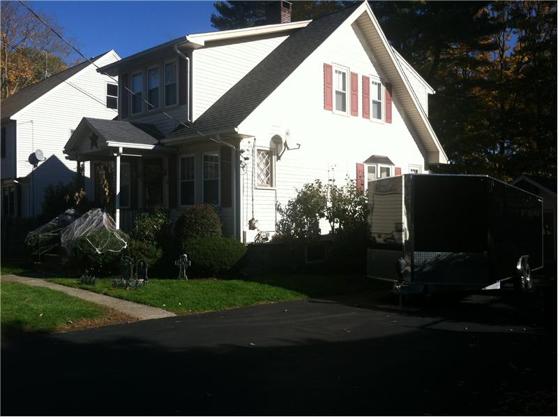
54 Liberty Square
Rockland, MA02370
$199,900
Single Family Residential
MLS#: 71464852
3 beds1 full bath1 half bath1440 sqft
Lot: 0.32acres Year built: 1920
1920 Character with the Style of TODAY!!
SOLD!!!!!!! They just don't build homes with character like this anymore!! This well built home located just outside Rockland Square is now available. This home has been stylishly updated over the years and is in move-in condition.
About the Neighborhood

Rockland was settled by European settlers, as a northeastern region of neighboring Abington in 1673. The town separated and incorporated as Rockland on March 9, 1874. It is named for the town's rocky nature, which was better suited for mills and industry than for farming. During King Philip's War, the town was the site of an encampment during his raids on the town of Scituate.
During the twentieth century, the town was the site of a portion of the landing strips of the South Weymouth Naval Air Station. The airstrip closed in 1996 as a part of the fourth round of closures under the Base Realignment and Closure Act.
In recent years, a growing number of artists have moved into the community, attracted by former factory buildings as a place to work and meet. Rockland was long noted in the South Shore Region as having the worst public streets. Pot holes on Rockland streets often caused tire or rim damage to motorists. These poor road conditions continued into the summer months long after winter had passed. Unlike other cities or towns in Massachusetts, Rockland's town insurance company refused to re-imburse motorists for vehicle damage as a result of Rockland's poor road conditions. In recent years, Rockland has made an effort to repair its roads.
Geography
According to the United States Census Bureau, the town has a total area of 10.1 square miles (26 km2), of which 10.0 square miles (26 km2) is land and 0.1 square miles (0.26 km2), or 0.79%, is water. Rockland ranks 307th out of 351 communities in the Commonwealth. Rockland is bordered by Weymouth to the northwest, Hingham to the northeast, Norwell to the northeast, Hanover to the east, Hanson to the south, Whitman to the southwest, and Abington to the west. Rockland is 8 miles (13 km) northeast of Brockton and 22 miles (35 km) south of Boston.
Rockland, as its name suggests, is dominated by rocky lands. There are several ponds throughout the town, including Accord Pond at the junction with Hingham and Norwell, and Studleys Pond (known to local residents as Reeds Pond) just south of Rockland Center, can be seen along Market Street. There are several brooks throughout town, one of which is sourced at the Abington-Rockland Reservoir near the northeast corner of town. Beech Hill lies at the south of town, and Wyman Fields lies to the north of it. There are several parks throughout the town, as well as a small town forest just south of the Naval Air Station.
A short stretch (2/3 of a mile long) of Massachusetts Route 3 crosses the northeast corner of town, granting access to Route 228, which terminates just south of the highway. Route 123 and Route 139 pass from west to east just south of the center of town, running coextensively for roughly 2/3 of a mile.
A spur of the Old Colony rail line formerly ran through the town; that line is now abandoned. The Old Colony Line does, however, pass through neighboring Weymouth, Abington and Whitman, as part of the Kingston-Route 3 line of the MBTA's commuter rail. There are stops in South Weymouth (alongside the Naval Air Station) and Abington (just south of Route 123), not far from the town line. There is no commercial air service in town; nearby national and international flights are available at Logan International Airport in Boston, or T. F. Green Airport in Rhode Island.
More details

Bobbie Files
Success! Real Estate
508-521-9480
Listed by: Bobbie Files ~ Success Real Estate
Copyright. RealBird Inc. All Rights Reserved.