  |
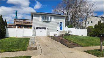
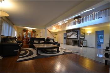
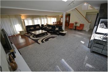
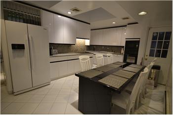
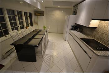
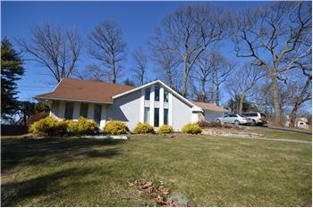
$1,288,000
Single Family Home 5 Bedrooms 3 Full Bathrooms 1 Half Bathroom Interior: 3,000 sqft Lot: 0.25 acre(s)
|
151 Village Road
|
Presented by Mark Hannigan |

|
Neighborhood InfoManhasset, New YorkFrom Wikipedia, the free encyclopedia
"Manhasset" redirects here. For other uses, see Manhasset (disambiguation).
Manhasset is a hamlet and census-designated place (CDP) in Nassau County, New York, on the North Shore ofLong Island. As of the 2010 United States Census, the population was 8,080. As with other unincorporated communities in New York, its local affairs are administered by the town in which it is located, the Town of North Hempstead, New York. Manhasset is a Native American term that translates to "the island neighborhood". In 2005, a Wall Street Journalarticle ranked Manhasset as the best town for raising a family in the New York metropolitan area.[1] The Manhasset area, settled by 1680, grew quickly after it began being served by the Long Island Rail Road in 1898. The LIRR provides access to New York City via the Manhasset and Plandome stations. Contents[hide]Geography[edit]Manhasset is located at 40°47′34″N 73°41′36″W (40.792754, −73.693263).[2] According to the United States Census Bureau, the CDP has a total area of 2.4 square miles (6.2 km2), of which, 2.4 square miles (6.2 km2) of it is land and 0.04 square miles (0.10 km2) of it (1.24%) is water. In addition to the unincorporated areas of Manhasset proper—North and South Strathmore, Strathmore Village, Strathmore Vanderbilt, Shorehaven, Terrace Manor and Norgate, those with a Manhasset address also include three incorporated villages—Munsey Park, Plandome and Plandome Heights—and parts of three others—Flower Hill, Plandome Manor and North Hills. The Plandomes[edit]The three Plandomes—Plandome, Plandome Manor and Plandome Heights—are in the north. Incorporated in 1911, the Village of Plandome is a tight knit community with frontage onManhasset Bay, the village center with its village green, and the wooded hills area. Its c.1912 Village Hall, a local landmark at the Green, once served as an elementary school. Its own LIRR Station is no more than a mile away from each home in the village. Plandome Manor, incorporated in 1931, is a beautiful section of Manhasset with many water front properties and an area near the railroad station. Plandome Heights, incorporated in 1929, has a rich history of Spanish architectural styles of white stucco exteriors and red-tile roofs, bordering downtown (unincorporated) Manhasset. Munsey Park[edit]In 1922, Louis Sherry, the wealthy confectioner, sold his estate and mansion to prominent newspaper publisher Frank A. Munsey. Over time, Munsey amassed 663 acres (268 ha) which included all of the present day Munsey Park, a small village where vintage street lamps lace narrow, tree lined roads and traditional homes grace manicured properties. Munsey had no heirs, no family and his entire estate and assets were left to the Metropolitan Museum of Art in New York . One portion of the Munsey lands—the Strathmore area and the magnificent chateau—was sold to Mrs. Graham Fair Vanderbilt. The 320 acres (129 ha) north were shaped into a model restricted community to reflect the generosity of Frank Munsey. The Metropolitan Museum developed a model community with all the homes built as authentic American colonial reproductions and the streets named for American artists. A walk along Copley pond in Munsey Park, there never were, nor are there today, anywhere in the village any adjacent or nearby homes of identical design. The Strathmores and Vanderbilts[edit]After a decade of providing a gracious setting for lawn parties and social festivities, the Vanderbilt family sold the 100 acre property to architect William Levitt who developed the Strathmore Vanderbilt community centered around the presence of the French Chateau at the end of the long and winding tree-lined drive. Strathmore Vanderbilt is located south of Quaker Ridge Rd. and to the west of Chapel Rd. Those living in Strathmore Vanderbilt receive deeded membership shares to the Strathmore Vanderbilt Country Club. East of Mill Spring Rd, the residents of Strathmore Village do not receive deeded shares. South Strathmore is the area in front of Strathmore Vanderbilt and Strathmore Village. It runs from Northern Blvd. back to Quaker Ridge Rd. and Hilltop Dr. North Strathmore is between Northern Blvd. and Munsey Park, north of the early 21st century library, and runs east. North Hills[edit]Once owned by John Hay Whitney, publisher of the New York Herald Tribune and Ambassador to England, the Whitney estate, known as Greentree, encompasses almost a quarter of the lands in Manhasset. Shelter Rock is an 1800-ton granite boulder, the largest known on Long Island, deposited by a glacier more than 11,000 years ago near what is now Shelter Rock Road, in the Village of North Hills. The Matinecock Indians used its 30 foot overhang for shelter in their village on the site. Many legends woven by both Indians and colonists who arrived in the 1600s are still told. By the 1900s a dozen families owned huge estates, including railroad magnate Nicholas F. Brady, who built Inisfada, once one of the largest houses in the country until the municipality approved a demolition permit in December 2013. Flower Hill[edit]Flower Hill is an incorporated village. A popular theory of how the name came to be is that there was an abundance of flowering cherry trees lining the road to one of the farms, as well as fields and meadows always filled with lovely wildflowers. Greentree[edit]Approximately a quarter of Manhasset lands still belong to the private 408 acres (1.65 km2) Greentree Whitney estate. The family mansion and surrounding lands are among the few remaining largely intact Long Island "Gold Coast" estates. The Greentree Foundation occupies the property as a conference center dedicated to international justice and human rights issues. Demographics[edit]As of the census[3] of 2000, there were 8,362 people, 2,831 households, and 2,185 families residing in the census-designated place (CDP). The population density was 3,505.8 per square mile (1,350.9/km²). There were 2,917 housing units at an average density of 1,223.0/sq mi (471.2/km²). The racial makeup of the CDP was 88.1% White, 2.3% African American, 0.9% Native American, 0.6% Asian, 0.1% Pacific Islander, 5.5% from other races, and 2.4% from two or more races. Hispanic or Latino of any race were 12.5% of the population. There were 2,831 households out of which 66.4% had children under the age of 18 living with them, 63.1% were married couples living together, 11.5% had a female householder with no husband present, and 22.8% were non-families. 20.2% of all households were made up of individuals and 10.0% had someone living alone who was 65 years of age or older. The average household size was 6.81 and the average family size was 5.73. In the CDP the population was spread out with 24.2% under the age of 18, 5.0% from 18 to 24, 27.5% from 25 to 44, 24.2% from 45 to 64, and 19.0% who were 65 years of age or older. The median age was 41 years. For every 100 females there were 87.4 males. For every 100 females age 18 and over, there were 81.7 males. According to a 2009 estimate,[4] the median income for a household in the CDP was $105,938, and the median income for a family was $130,909. The per capita income in the CDP was $51,698. 5.7% of the population and 3.9% of families were below the poverty line. Out of the total people living in poverty, 5.4% are under the age of 18 and 6.9% are 65 or older. History[edit]The Matinecock had a village on Manhasset Bay. These Native Americans called the area Sint Sink, meaning "place of small stones."[5][6] They made wampum from oyster shells. In 1623, the area was claimed by the Dutch West India Company and they began forcing English settlers to leave in 1640. A 1643 land purchase made it possible for English settlers to return to Cow Neck (the peninsula where present-day Port Washington, Manhasset and surrounding villages are located.).[7] Manhasset Bay was previously known as Schout's Bay (a schout being roughly the Dutch equivalent of a sheriff), Martin Garretson's Bay (Martin Garretson was the Schout at one point), and later Cow Bay or Cow Harbor.[6] Cow Neck was so called because it offered good grazing land. By 1659, there were over 300 cows and 5 mi (8 km) fence separating Cow Neck from the areas south of it. The settlers came to an agreement that each of them could have one cow on the neck for each section of fence the individual had constructed. The area was more formally divided among the settlers when the fence was removed in 1677. Manhasset took on the name Little Cow Neck, Port Washington was known as Upper Cow Neck.[7] During the American Revolution, Little Cow Neck suffered at the hands of the British. Many structures and properties, such as the 1719 Quaker Meeting House were burned, seized or damaged. The Town of North Hempstead separated from the Town of Hempstead in 1784 because the South, inhabited mainly by Church of England people, was loyal to the king. The Northern communities and villages, dominated by Yankee Congregationalists supported independence.[7] In 1801 it cost 2 cents to travel between Roslyn and Spinney Hill on North Hempstead Turnpike, the newly opened toll road (now Northern Boulevard).[7] The Manhasset name was adopted in 1840 and comes from the native word "Manhansett", meaning "island neighborhood." Dairy farming was still a major endeavor but the oyster industry was also on the rise. In 1898, the Long Island Railroad arrived, bringing with it wealthy New Yorkers looking for country homes with easy transportation to more urban areas of New York City.[7] Manhasset Valley and the area called Spinney Hill attracted a number of skilled workers and immigrant families.[7] The North Hempstead Town Hall opened in Manhasset on Plandome Road in 1907.[7] Town councilmen had previously been meeting in Roslyn taverns after North Hempstead split away from Hempstead in 1775. The Valley School, serving Manhasset's African American community, was closed in the 1960s by a desegregation lawsuit. It is still standing and is currently used as a community center. The centrally located and antiquated Plandome Road School was demolished in the 1970s, having been replaced by the new Shelter Rock School. It was surprisingly well built and took significant time and effort in order to be demolished. Currently, the Mary Jane Davies Park sits on the site of the school. Schools[edit]
The Manhasset School District covers not only the unincorporated areas discussed in the census reports, but several incorporated villages including Plandome, Plandome Manor, Munsey Park and part of Flower Hill. Manhasset High School is rated among the top in the country. In the 2010 Newsweek magazine's annual list of the top American high schools, Manhasset is ranked 87th nationally out of the 1,700 schools evaluated.[8] Manhasset has a locally operated School Community Association (SCA) instead of electing to be a local chapter of theParent Teacher Association. The SCA, which boasts great support within the community, annually hosts the SCA fair at Munsey Park School to raise money. Membership dues and profits from fund-raising efforts benefit the schools in Manhasset; no percentage of funds goes to a state or national offices of a larger organization, thus all monies raised benefit the Manhasset schools directly.[9] Sports[edit]Manhasset High School St. Mary's Economy[edit]Manhasset is well known for its high-end premium open-air shopping center, theAmericana Manhasset. The center is situated along Northern Boulevard's "Miracle Mile" which is referenced in Billy Joel's 1980 hit "It's Still Rock and Roll to Me". The Americana first opened in 1956 as a simple community-style shopping mall; however, in the early 2000s gradually it catered to luxury boutiques such as Ralph Lauren, Brooks Brothers, Prada, Giorgio Armani, Chanel, Theory,[10] Louis Vuitton, Hermès, and Burberry, among others. In addition, a short distance away from the Miracle Mile is Lord & Taylor, which is historically the first branch store in America. In addition to Lord & Taylor, Manhasset has supported branches of some of the most well known stores in New York over the years—B. Altman and Company, Bonwit Teller, Abraham & Straus, Best & Co., Arnold Constable, Franklin Simon & Co., Peck & Peck, W. & J. Sloane, J.J. Newberry and Waldbaum's. The old commercial center of Manhasset is situated around the railroad station on Plandome Road, where the LIRRconnects directly into Manhattan for a 37-minute commute. The area has bakeries, pizzerias, delis, bars, coffee shops, an AT&T Cell Phone Store, and a movie theater. Centralized in town is a small park and a gazebo. The public library is more distant, having moved a block south of its location on Onderdonk Avenue to the corner of Onderdonk Ave. and Northern Boulevard, next door to the historic Quaker Meeting House. The North American headquarters of Sabena were located in a 36,000 square feet (3,300 m2) office building in Manhasset. In April 2002 Knightsbridge Properties Corp. bought the building for $4.9 million. Due to the bankruptcies of Sabena and Swissair, the real estate deal took over a year to finish. During that month the building was 30% occupied. Sabena was scheduled to move out of the building on May 10, 2002. The buyer planned to spend an additional $2 million to convert the building into a multi-tenant, Class A office and medical facility.[11] In popular culture[edit]Movies
Television
Literature
Music
International relations
Notable people[edit]
|
|||||||||||||||||||||||||||||||||||||||||||||||||