This property at E Valley Parkway#101 , Escondido, CA92027 has listed by Michael J Blue but has not been updated for quite some time. Please contact the listing agent and broker for up to date information.
E Valley Parkway#101
Escondido, CA92027
$69,900
Mobile Home
MLS#: 120037782
3 beds2 full baths1404 sqft
Lot: 3999.00sqft Year built: 2006
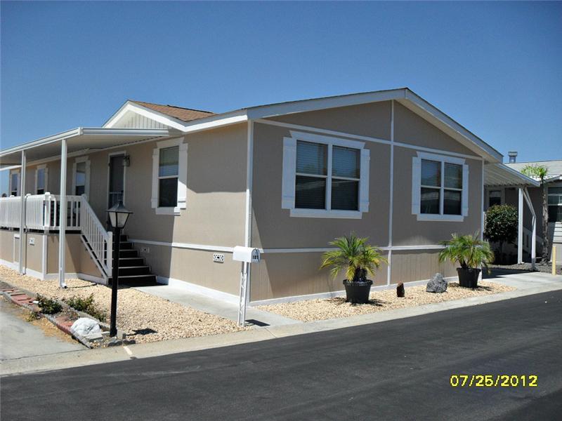
2006 Manufactured Home in Escondido (San Diego) CA
Owner will carry with $20,000 down OAC, payment is $448.52 or obtain your own financing. Newer manufactured home features 3 full size bedrooms, master bath with soaking tub, separate shower, 2 sink basin, laundry room, gas applainces, large living room, covered and white picket fence front deck, 2 car covered carport, 5 ton A/C unit, storage shed, easy care landscaping.
About the Neighborhood
Escondido, California
| Escondido | |
|---|---|
| City | |
| City of Escondido | |
 |
|
| Nickname(s): Hidden Valley; The Hidden City; The Heart of San Diego North; Esco | |
 |
|
| Coordinates: 33°7′29″N 117°4′51″W / 33.12472°N 117.08083°WCoordinates: 33°7′29″N 117°4′51″W / 33.12472°N 117.08083°W | |
| Country | |
| State | |
| County | San Diego |
| Incorporated | October 8, 1888 |
| Government | |
| • Type | Council-Manager |
| • Mayor | Sam Abed |
| Area[1] | |
| • Total | 36.989 sq mi (95.801 km2) |
| • Land | 36.813 sq mi (95.345 km2) |
| • Water | 0.176 sq mi (0.456 km2) 0.48% |
| Elevation | 646 ft (197 m) |
| Population (2010) | |
| • Total | 143,911 |
| • Rank | 4th in San Diego County 38th in California 171st in the United States |
| • Density | 3,900/sq mi (1,500/km2) |
| Time zone | PST (UTC-8) |
| • Summer (DST) | PDT (UTC-7) |
| ZIP Code | 92025-92027, 92029 |
| Area code(s) | 760 and 442 (overlay plan) |
| FIPS code | 06-22804 |
| GNIS feature ID | 1652706 |
| Website | www.escondido.org |

Escondido (![]() /skndido/ ES-kn-DEE-doh; Spanish for "hidden") is a city occupying a shallow valley ringed by rocky hills, just north of the city of San Diego, California. Founded in 1888, it is one of the oldest cities in San Diego County. The city had a population of 143,911 at the 2010 census. Its municipal government set itself an operating budget limit of $426,289,048 for the fiscal year 2010-2011.[2] The city is known as Eskondiid in Diegueño.[3] A 2005 nationwide study of the most conservative cities in America ranked Escondido #11 out of 25.[4]
/skndido/ ES-kn-DEE-doh; Spanish for "hidden") is a city occupying a shallow valley ringed by rocky hills, just north of the city of San Diego, California. Founded in 1888, it is one of the oldest cities in San Diego County. The city had a population of 143,911 at the 2010 census. Its municipal government set itself an operating budget limit of $426,289,048 for the fiscal year 2010-2011.[2] The city is known as Eskondiid in Diegueño.[3] A 2005 nationwide study of the most conservative cities in America ranked Escondido #11 out of 25.[4]
Contents[hide] |
[edit] History
The Escondido area was first settled by the Luiseño, who established campsites and villages along the creek running through the area. They named the place "Mehel-om-pom-pavo." The Kumeyaay migrated from areas near the Colorado River, settling both in the San Pasqual Valley and near the San Dieguito River in the southwestern and western portions of what is now Escondido. Most of the villages and campsites today have been destroyed by development and agriculture.[5]
Spain controlled the land from the late 18th century to the early 19th century, and established many missions in California to convert the indigenous people. When Mexico gained its independence from Spain, the local land was divided into large ranchos. Most of what is now Escondido occupies the former Rancho Rincon del Diablo("Devil's Corner"), a Mexican land grant given to Juan Bautista Alvarado (not the governor of the same name)in 1843 by Governor Manuel Micheltorena. Alvarado was a Regidor of Los Angeles at the time, and the first Regidor of the pueblo of San Diego. The southern part of Escondido occupies the former Rancho San Bernardo, granted in 1842 and 1845.[6]
In 1846, during the Mexican-American War, the Battle of San Pasqual was fought southeast of Escondido. This battle pitted Mexican forces under Andrés Pico (brother of then-California-governor Pío Pico) against Americans under Stephen W. Kearny, Archibald Gillespie, and Kit Carson. A park in Escondido is named for Carson.
In 1853, pro-Southern Copperheads proposed dividing the state of California to create a new Territory of Colorado (at this time the territory that would become the state of Colorado was named "Jefferson"). San Diego Judge Oliver S. Witherby suggested placing the capitol of the new territory in Rancho Rincon del Diablo. He envisioned a railroad connecting San Diego to Fort Yuma through an area about two miles (3 km) south of the current Escondido site, heading east through San Pasqual. He planned to profit from the town that he believed would be established from the dividing point on the railroad below the eastern hills.[7]
With a series of deeds in 1855 and 1856, the rancho was transferred from the heirs of Juan Bautista Alvarado to Witherby.[6]
The proposal for splitting the state and creating the new territory passed in the California legislature, but died in Congress in the run-up to the Civil War.[6] It was effectively killed in 1861 when Congress organized the Territory of Colorado in the area previously occupied by the Jefferson Territory. With Witherby's vision of owning a bustling state capitol unrealized, he set up a mining operation on the rancho instead.[7]
In 1868, Witherby sold the rancho for $8000 to Edward McGeary and John, Josiah, and Matthew Wolfskill. McGeary owned half the rancho, while the three Wolfskill brothers each owned an equal share of the other half. John Wolfskill farmed sheep, horses, and cattle on the rancho for a number of years. Wolfskill had frequent conflicts with the Couts family, owners of the neighboring Guajome, Buena Vista, and San Marcos ranchos, over grazing lands and watering holes.[6]
[edit] Incorporation and growth
The city was home to a large Spanish-speaking population in the first census, in 1850, but after the U.S. won the war, non-Hispanic settlers came to Southern California in increasing numbers. The decade of the 1880s is known as the "Southern California Land Boom" because so many people moved to the state.
In October 1883, a group of Los Angeles investors purchased Rancho Rincon del Diablo. This group sold the land to the newly formed Escondido Company in 1884. On December 18, 1885, investors incorporated the Escondido Land and Town Company, and in 1886 this company purchased the 12,814-acre (52 km2) area for approximately $100,000.[6] Two years later, in 1888, Escondido was incorporated as a city; the vote was 64 in favor of cityhood with 12 votes against. Railroads such as the Santa Fe and Southern Pacific were laid in the 1880s. The opening of U.S. Route 395 in 1930 boosted economic growth in Escondido.
Escondido was primarily an agricultural community, growing muscat grapes initially. After a dam was built in 1894-5 to form what is known today as Lake Wohlford, orange and lemon trees were planted in large numbers, as were olive and walnut trees. By the 1960s, avocados became the largest local crop. Since the 1970s, Escondido has lost most of its agricultural land to housing developments.
[edit] Geography

Escondido is located at 33°7'29" North, 117°4'51" West (33.124794, -117.080850).[8]
According to the United States Census Bureau, the city has a total area of 37.0 square miles (96 km2). 36.8 square miles (95 km2) of it is land and 0.2 square miles (0.52 km2) of it is water. The total area is 0.48% water.
The city is growing at a rapid rate with new communities like Hidden Trails appearing at the east end of East Valley Parkway. The city proper is surrounded by several sparsely populated unincorporated communities. These include Jesmond Dene and Hidden Meadows to the north; Felicita Park to the southwest; and Rincon Del Diablo to the southeast. Residents of these communities have Escondido mailing addresses and zip codes, and their children are sometimes assigned to Escondido schools, but residents of these communities cannot participate in city elections.[citation needed]
The city contains several neighborhoods including:
- Downtown Escondido centers around Grand Avenue between Centre City Parkway and Palomar Hospital. The city's general plan defines the Downtown Specific Plan Area as approximately 460 acres (1.9 km2) bounded by Centre City Parkway on the west, Hickory and Ivy Streets on the east, Washington Avenue on the north, and Fifth Avenue on the south, with an additional narrow section extending west along Valley Parkway to Interstate 15.[9]
- Old Escondido is bounded by Escondido Boulevard on the west, Chestnut Street on the east, Fifth Avenue on the north, and Thirteenth Avenue on the south. This area is made up of mostly single-family residential housing.[10]
The Escondido Creek bisects the city. It originates at the Lake Wohlford Dam in the northeast, passes through downtown and leaves the city through the Harmony Grove area in the southwest before eventually emptying into the San Elijo Lagoon. The creek path through the city was developed into a concrete flood control channel in the 1960s. A Class I bicycle path runs along most of the channel's length.[11]
The community of Valley Center is located just north of Escondido. Valley View Casino, owned by the San Pasqual Band of Diegueno Mission Indians, is located in Valley Center.
[edit] Climate
Escondido tends to have a typical Mediterranean climate with warm summers and cool wet winters. Owing to its inland proximity it is considerably warmer than coastal cities like San Diego, Carlsbad or Oceanside. Yearly precipitation averages around 15 inches (380 mm) and can vary considerably from year to year. More than 80% of all precipitation takes place from November through March. Snow is virtually unheard of though occasionally Springtime thunderstorms will drop small hail. The climate is mild enough to allow widespread cultivation of avocados and oranges. Escondido is located in a plant hardiness zone 9.
| [hide]Climate data for Escondido | |||||||||||||
|---|---|---|---|---|---|---|---|---|---|---|---|---|---|
| Month | Jan | Feb | Mar | Apr | May | Jun | Jul | Aug | Sep | Oct | Nov | Dec | Year |
| Average high °F (°C) | 68 (20) |
69 (21) |
70 (21) |
75 (24) |
77 (25) |
84 (29) |
89 (32) |
89 (32) |
87 (31) |
81 (27) |
74 (23) |
69 (21) |
77.7 (25.4) |
| Average low °F (°C) | 42 (6) |
45 (7) |
47 (8) |
50 (10) |
54 (12) |
58 (14) |
61 (16) |
63 (17) |
61 (16) |
55 (13) |
46 (8) |
42 (6) |
52.0 (11.1) |
| Precipitation inches (mm) | 3.4 (86) |
3.2 (81) |
3.3 (84) |
1.0 (25) |
0.3 (8) |
0.1 (3) |
0.1 (3) |
0.0 (0) |
0.2 (5) |
0.4 (10) |
1.3 (33) |
1.8 (46) |
15.1 (384) |
| Source: Weatherbase [12] | |||||||||||||
[edit] Lakes
Three lakes are located in or near Escondido, all of which allow boating and fishing[citation needed]:
- Dixon Lake is located in the north.[13]
- Lake Wohlford is located on the north eastern fringe of the city limits.[14]
- Lake Hodges is located just south of the city. A part of Lake Hodges is crossed by Interstate 15 via the Lake Hodges Bridge. Often this part of the lake is dry.
[edit] Demographics
| Historical populations | |||
|---|---|---|---|
| Census | Pop. | %± | |
| 1890 | 541 |
|
|
| 1900 | 755 | 39.6% | |
| 1910 | 1,334 | 76.7% | |
| 1920 | 1,789 | 34.1% | |
| 1930 | 3,421 | 91.2% | |
| 1940 | 4,560 | 33.3% | |
| 1950 | 6,544 | 43.5% | |
| 1960 | 16,377 | 150.3% | |
| 1970 | 36,792 | 124.7% | |
| 1980 | 64,355 | 74.9% | |
| 1990 | 108,635 | 68.8% | |
| 2000 | 133,559 | 22.9% | |
| 2010 | 143,911 | 7.8% | |
[edit] 2010 census
In the 2010 United States Census,[15] Escondido had a population of 143,911. The population density was 3,890.7 people per square mile (1,502.2/km²). The racial makeup of Escondido was 60.4% White (40.4% non-Hispanic white), 2.5% African American (2.1% non-Hispanic black), 1.0% Native American, 6.1% Asian, 0.2% Pacific Islander, 25.4% from other races, and 4.4% from two or more races. Hispanic or Latino of any race were 48.9% of the population.
The Census reported that 141,792 people (98.5% of the population) lived in households, 1,333 (0.9%) lived in non-institutionalized group quarters, and 786 (0.5%) were institutionalized.
There were 45,484 households, out of which 18,989 (41.7%) had children under the age of 18 living in them, 23,535 (51.7%) were opposite-sex married couples living together, 6,082 (13.4%) had a female householder with no husband present, 3,115 (6.8%) had a male householder with no wife present. There were 3,121 (6.9%) unmarried opposite-sex partnerships, and 343 (0.8%) same-sex married couples or partnerships. 9,528 households (20.9%) were made up of individuals and 4,235 (9.3%) had someone living alone who was 65 years of age or older. The average household size was 3.12. There were 32,732 families (72.0% of all households); the average family size was 3.57.
The population was spread out with 39,778 people (27.6%) under the age of 18, 15,455 people (10.7%) aged 18 to 24, 41,043 people (28.5%) aged 25 to 44, 32,551 people (22.6%) aged 45 to 64, and 15,084 people (10.5%) who were 65 years of age or older. The median age was 32.5 years. For every 100 females there were 98.2 males. For every 100 females age 18 and over, there were 96.1 males.
There were 48,044 housing units at an average density of 1,298.9 per square mile (501.5/km²), of which 23,759 (52.2%) were owner-occupied, and 21,725 (47.8%) were occupied by renters. The homeowner vacancy rate was 2.2%; the rental vacancy rate was 6.0%. 70,936 people (49.3% of the population) lived in owner-occupied housing units and 70,856 people (49.2%) lived in rental housing units.
[edit] 2000 census
As of the census[16] of 2000, there are 133,559 people, 43,817 households, and 31,153 families residing in the city. The population density is 1,421.4/km² (3,680.9/mi²). There are 45,050 housing units at an average density of 479.4/km² (1,241.6/mi²). The racial makeup of the city is 67.82% White, 2.25% African American, 1.23% Native American, 4.46% Asian, 0.23% Pacific Islander, 19.19% from other races, and 4.81% from two or more races. 38.70% of the population are Hispanic or Latino of any race.
There are 43,817 households out of which 39.1% have children under the age of 18 living with them, 53.9% are married couples living together, 11.7% have a female householder with no husband present, and 28.9% are non-families. 22.4% of all households are made up of individuals and 10.1% have someone living alone who is 65 years of age or older. The average household size is 3.01 and the average family size is 3.50.
In the city the population is spread out with 29.7% under the age of 18, 10.4% from 18 to 24, 31.4% from 25 to 44, 17.5% from 45 to 64, and 11.0% who are 65 years of age or older. The median age is 31 years. For every 100 females there are 98.4 males. For every 100 females age 18 and over, there are 96.1 males.
The median income for a household in the city is $42,567, and the median income for a family is $48,456. Males have a median income of $32,627 versus $27,526 for females. The per capita income for the city is $18,241. 13.4% of the population and 9.3% of families are below the poverty line. Out of the total population, 17.9% of those under the age of 18 and 5.7% of those 65 and older are living below the poverty line.
The city can be divided into two demographically distinct areas. Peripheral hilly areas to the north, southeast, and southwest are relatively wealthy and populated by non-Hispanic whites, and flat areas adjacent to the downtown are predominantly Hispanic. As of 2006-07 school year, non-Hispanic white children comprised 71.7% of all students in Bernardo Elementary School (southwest), 60.8% of all students in L.R. Green Elementary School (southeast), and 54.7% of all students in Reidy Creek Elementary School (north); on the other hand, Farr Avenue, Pioneer and Lincoln Elementary schools (three large schools just north of the downtown) all have more than 85% of Hispanic and less than 6% non-Hispanic white students.
[edit] Crime
In 2007, the city ranked #65 by violent crimes per capita and #58 by property crimes per capita among 165 cities in California with populations greater than 50,000. Compared with the 12 largest cities in San Diego County, it ranked 6th in both categories. Its crime rate was lower in both categories than San Diego, El Cajon, and National City; higher in both categories than San Marcos, Carlsbad, Encinitas, and Santee. Escondido had a higher violent crime rate but lower property crime rate than La Mesa and Chula Vista; it had a lower violent crime rate but higher property crime rate than Vista and Oceanside.
In 2009, 629 violent crimes and 3,880 property crimes were reported in Escondido. There were four murders and non-negligent manslaughters, 42 rapes, 249 robberies, 334 aggravated assaults, 779 burglaries, 2,402 larceny thefts, 699 vehicle thefts, and 23 arsons.[17]
In 2010, Escondido saw a 5 percent drop in violent crime, with only 597 reported violent crimes according to the Escondido Police Officer's Association. However, there was a 3.9 percent increase in the number of property crimes, including residential and commercial burglaries, from 3,880 in 2009 to 4,033 in 2010, according to FBI statistics.[18]
[edit] Economy
Residents work in a range of industries. Out of the approximately 64,000 employed civilian residents over the age of 16, 15% work in educational, health care and social services; 13% in retail trade; 13% in construction; 12% in professional, scientific, management, administrative, and waste management services; 11% in arts, entertainment, recreation, and accommodation and food services; 11% in manufacturing; and 11% in other services.[19]
Realty Income is among the companies based in Escondido.
[edit] Top employers
According to the City's 2009 Comprehensive Annual Financial Report,[20] the top employers in the city are:
| # | Employer | # of Employees |
|---|---|---|
| 1 | Palomar Medical Center | 2,664 |
| 2 | Escondido Union School District | 1,795 |
| 3 | City of Escondido | 1,075 |
| 4 | Escondido Union High School District | 715 |
| 5 | North County Transit District | 484 |
| 6 | ARS National Services | 439 |
| 7 | Nordstrom | 418 |
| 8 | Ne-Mo's Bakery | 352 |
| 9 | Palomar College | 340 |
| 10 | The Home Depot | 333 |
[edit] Arts and culture
[edit] Downtown

Downtown has become more active in the past few years with the opening of restaurants, cafes, and galleries. Every Friday night from April through September, Steve Waldron and a handful of friends host the popular "Cruisin' Grand", where the public can show and view hot rods and historic cars. A different car club and/or featured attraction (for example, antique fire trucks, nitro night, midget and sprint cars) is highlighted each week. Cruisin' Grand also features a DJ, hula hoop contests for children, and the awarding of trophies.
In addition to the many art galleries on Grand, a branch of the Mingei International Museum recently opened there.(now recently closed) This museum displays handcrafts from around the world. One block off Grand Ave. is Grape Day Park with the civic center and the California Center for the Arts, which features two theaters, a visual arts museum, an educational complex, and a conference center. The Escondido Children's Museum and the Escondido History Center, two independent non-profit museums, are located in Grape Day Park. The Children's Museum features hands-on exhibits and programs for children up to 10 years of age, with an authentically regional perspective on natural and social science. The History Center features the city's original Santa Fe Depot, first library, Victorian house, barn, and blacksmith shop. The Pioneer Room of Escondido Public Library (located in the Mathes Center building next to the Main Library) offers photographs, maps, oral histories, genealogical collections, directories and yearbooks documenting Escondido's history.[21]
[edit] Sports
|
|
This article needs additional citations for verification. (April 2012) |
From 1964–1968, the San Diego Chargers held training camp in Escondido.[22]
In 1981, Escondido National Little League became the 19th[23] team to make it to the Little League World Series from the state of California. The team was first District 31 champions, then District 8 champions.[24] They then won the Southern California Divisional Tournament at Youth Athletic Park by beating San Bernardino Civitan 3-2 in the quarterfinals, then beating Granada Hills American 5-1 in the semifinals and then beating Ladera National 7-5 in the finals to earn a trip to the Western Regional. At the Western Regional in San Bernardino, the Escondido team won four straight games to earn the trip to Williamsport.[25]
In October 2010, Merritt Paulson, owner of the AAA Portland Beavers franchise, announced that the team was being sold to the North County Baseball ownership group, led by Jeff Moorad, part-owner and CEO of the Beavers parent team, the San Diego Padres. The ownership group is in discussions to build a stadium in Escondido to become operational for the 2012 baseball season at the earliest. In December 2010, the Escondido city council voted to go ahead with the ballpark. The stadium is slated to open in April 2013.[26][27]
However, the plan to move the team fell through in January 2012 and the current Tucson Padres are left on their own. It's possible a relocated team of the class A California League most likely a San Diego Padres affiliated team will play in Escondido next year.[28]
[edit] Parks and recreation
[edit] Parks
Escondido has fifteen parks.[29]
- Daley Ranch is a 3,058-acre (12.38 km2) conservation area acquired in 1996 by the City of Escondido and is managed in perpetuity for the preservation of a biologically unique and diverse habitat area of regional importance. Daley Ranch has over 20 miles (32 km) of hiking, mountain biking, and equestrian trails. Six distinct trails cover most of the property. Most popular are the Boulder Loop Trail (2.4 miles) which affords views of Escondido, and the Ranch House Loop (2.5 miles), which passes two small ponds and the site of Daley's original log cabin.
- El Norte Park is a small "green lung" park, off El Norte Parkway in northern Escondido. It features mature trees and a kids playground.

- Grape Day Park is located behind the Escondido City Hall and the performing arts complex. This park was named after the annual grape day harvest, an event held on the first Saturday after Labor Day. Dogs are not allowed in Grape Day Park.[30]
- Jesmond Dene
- Kit Carson: Queen Califia's Magical Circle, the last major international work by French artist Niki de Saint Phalle, is located in Kit Carson Park. De Saint Phalle, a colleague of Salvador Dalí and Jasper Johns, is best known for her Stravinsky Fountain, located in Paris, France. The artist chose Escondido as the site for her final work because it reminded her of Italy.

- Dixon Lake supplies Escondido with fresh water. Swimming is not allowed, but fishing is, and boats are available for hire. Dixon Lake has about 34 camp sites which look out over the lake, or over Escondido. While entrance to the park is free, the city charges $5.00 (in 2010) for taking a car into the park. However, ample free parking is available outside the gate.
- Lake Wohlford is in the north east corner of Escondido. The lake has some walking trails around the perimeter, and allows fishing.
- Mountain View
- Rod McLeod
- Washington Park is an urban park located on the eastern side of central Escondido. It features lighted facilities for baseball, softball, tennis and basketball, a 25-yard swimming pool and water slide, and a smaller children's pool. The park's numerous mature trees create plenty of shady areas and tables are provided for picnics.[31]
- Westside
- Frances Ryan Park is a 67 acres (270,000 m2) complex of soccer fields, supported by a concession stand and public restrooms. The park is adjacent to Valley High School in eastern Escondido at the corner of Valley Parkway and El Norte Parkway. As of October 2010, the park features 7 soccer fields, 5 of which have lights for night time practice and play. The park is named for a former teacher at Escondido High School. Dogs are not allowed in Ryan Park.[32]
- Grove Park was so named to recognize the city's agricultural history. It was built about 2008 (approximate date). It is about 4.5 acres (18,000 m2) in size and is located in the Mission Park neighborhood.
- Felicita County Park
[edit] San Diego Zoo Safari Park
The San Diego Zoo Safari Park (also called by its former name, "Wild Animal Park") is located near Escondido, in the San Pasqual Valley. It is the sister park to the San Diego Zoo. The Safari Park shows animals in open habitats.
[edit] Stone Brewing Company
In 2006, Stone Brewing Company moved its headquarters and brewery from San Marcos, California to a new, much larger facility in the Quail Hills area of Escondido.[33]
[edit] Deer Park Buddhist Monastery
Deer Park Monastery is a Buddhist sanctuary that occupies 400 acres (1.6 km2) in the hills north of Escondido and west of Daley Ranch. It is one of two monasteries in the United States under the direction of a well-known Zen teacher Thich Nhat Hanh. Deer Park Monastery is home to 27 Buddhist monks and nuns; it frequently hosts events and retreats that bring people from all over the western United States and from abroad.
[edit] Government
| Sister cities[34][35] |
|---|
| Itoshima, Japan |
[edit] Local

Escondido is governed by a mayor-council system. The city council consists of a mayor and four City Council members. Along with the City Treasurer, they are elected at large to four-year terms. The current mayor is Sam Abed. Current City Council members are Olga Diaz, Marie Waldron, Ed Gallo, and Michael Morasco.[36][37] The current City Manager is Clay Phillips. The current City Treasurer is Kenneth Hugins.[38] The most recent election was held on November 2, 2010.[39]
Due to the public outcry and legal challenges to the aforementioned housing ordinance, and the election of Olga Diaz to the City Council, it has since ceased any overt attempts to lower the illegal immigrant population in the city (which, council member Sam Abed's estimates is as much as 35,000, or 25% of the city population in 2006[40]), and focused on "quality of life" issues instead. Periodic police checkpoints are instituted to catch unlicensed drivers. An active area of debate is an overnight parking ordinance that would limit the number of cars each household can legally park on city streets.[41] The city is estimated to have lost as much as a quarter of its non-citizen population between 2006 and 2007. Latino activists attribute this to a perception of the city as hostile to immigrants.[42]
The City of Escondido is a member of the San Diego Association of Governments (SANDAG).[43]
[edit] State and federal
In the state legislature Escondido is located in the 38th Senate District, represented by Republican Mark Wyland, and in the 74th and 75th Assembly District, represented by Republicans Martin Garrick and Nathan Fletcher respectively. Federally, Escondido is located in California's 50th congressional district, which has a Cook PVI of R +5[44] and is represented by Republican Brian Bilbray.
In the United States presidential election of 2008, 53.3% of voters residing in incorporated Escondido voted for John McCain, 44.9% voted for Barack Obama, and 1.8% voted for one of the third-party candidates. Unincorporated areas were considerably more conservative: among voters in neighborhoods of Rincon Del Diablo, Hidden Meadows, and Valley Center, 62.3%, 65.5%, 66.9% of voters respectively cast their votes for John McCain. In a survey conducted by The Bay Area Center for Voting Research, it found that Escondido was the 11th most conservative city in the United States.[45]
[edit] Education
Escondido is served by the Escondido Union School District,[46] the Escondido Union High School District,[47] and the San Pasqual Union School District. The city has 19 elementary, five middle, and seven high schools.
Public high schools:
- Escondido High School
- Orange Glen High School
- San Pasqual High School
- Classical Academy High School
- Escondido Charter High School
- Center City High School
- Valley High School[48]
Middle schools:
- Bear Valley Middle School
- Del Dios Middle School
- Hidden Valley Middle School
- Mission Middle School
- Rincon Middle School
Elementary Schools
- Bernardo Elementary
- Central Elementary
- Classical Academy
- Coastal Academy
- Conway Elementary
- Farr Avenue Elementary
- Felicita Elementary
- Glen View Elementary
- Heritage K-8 Charter
- Juniper Elementary
- L. R. Green Elementary
- Lincoln Elementary
- Miller Elementary
- Nicolaysen Community Day
- North Broadway Elementary
- Oak Hill Elementary
- Orange Glen Elementary
- Pioneer Elementary
- Reidy Creek Elementary
- Rock Springs Elementary
- Rose Elementary
There is a wide range of API scores for Escondido schools, reflecting the demographic diversity of the city. As of 2009,[49] two elementary schools in the district scored above the 80th percentile of all schools in the state, and nine elementary schools scored below the 20th percentile.
The Escondido Public Library system consists of the Main Branch, the East Valley Branch, Pioneer Room, Computer Center, and a bookmobile.
[edit] Infrastructure
[edit] Transportation
Two highways serve Escondido: Route 78 and Interstate 15. Route 78 enters from the west as a freeway which ends at Broadway. The highway follows surface streets and leaves the city heading east into the San Pasqual Valley.
The North County Transit District (NCTD) operates local bus service, with the Escondido Transit Center serving as a hub. The transit center has connections to both the San Diego Metropolitan Transit System and the Riverside Transit Agency.
The Sprinter light rail line, operated by NCTD, links the transit center to Oceanside using the existing 22-mile (35 km)-long Escondido Branch trackage of the San Diego Northern Railroad. The rail line opened in 2008, making Escondido one of the first cities in the United States to operate Desiro-class diesel multiple units manufactured by Siemens in Germany. At the Oceanside Transit Center, the Sprinter connects to three commuter rail lines (the Coaster, the Metrolink Orange County Line, and the Metrolink Inland Empire-Orange County Line) and Amtrak's Pacific Surfliner regional rail line.
The California High Speed Rail Authority listed Escondido as a stop along the proposed high-speed rail system running from Southern to Northern California.[50] A section of the line between San Francisco and Los Angeles was approved by voters in the November 2008 elections.
[edit] Utilities
San Diego Gas & Electric is the electric utility for the city.[51] The City of Escondido Water Utilities serves most customers within the City while Rincon del Diablo Municipal Water District serves potable and recycled water to the greater Escondido valley and some portions of the incorporated city.[52]
[edit] Health care
Palomar Medical Center is a hospital located east of downtown. It is the only designated trauma center in northern San Diego County.[53] A second hospital, Palomar West, is under construction southwest of the interchange between Interstate 15 and State Route 78. It is scheduled to open in 2012.[54]
[edit] Notable natives and residents
- Anacani: featured singer with Lawrence Welk orchestra
- Tom Anderson: co-founder of MySpace[55]
- Lester Bangs: rock music critic
- Ken Block: rally car driver, and founder of DC Shoes.
- Benjamin Britten: English composer, famous for his opera "Peter Grimes"[56]
- E. H. Bronner: soapmaker
- Ray Conniff: bandleader and arranger
- Pete Coscarart: former Brooklyn Dodger
- Gavvy Cravath: right fielder for the Philadelphia Phillies
- Richard Denning: actor
- Robert Klark Graham: eugenicist and inventor, founder of the Repository for Germinal Choice ("Nobel Prize Sperm Bank")
- Steve Hendrickson: former Chargers Player
- Brittany Hogan: former Miss California
- Randy Johnson: former Major League player with Atlanta Braves, current Special Asst to Oakland A's GM Billey Beane, Graduate of Escondido High School
- Jacque Jones: former baseball player for the Minnesota Twins
- Jovan Kirovski: forward for the L.A. Galaxy MLS team
- Elisabeth Kübler-Ross: founder and resident of the "Shanti Nilaya" (Home of Peace), retreat in Escondido in the late 1970s and early 1980s
- Shannon MacMillan: professional soccer player and graduate of San Pasqual High School
- Deborah Jeane Palfrey: the so-called D.C. Madam[57]
- Robbie Peralta MMA UFC Fighter
- Mark Redman: professional baseball player and graduate of Escondido High School
- Steve Reeves: bodybuilder[58]
- Travis Ryan: lead vocalist of Cattle Decapitation[59]
- Brett Salisbury: college football quarterback, author of The Transform Diet, and member of Escondido's 1981 Little League World Series team.
- Sean Salisbury: former ESPN anchorman and former NFL quarterback; graduate of Orange Glen High School
- Riley Steele: pornographic actress
- Randy Vasquez: actor
- Eric Weddle: #32 of San Diego Chargers resides in Escondido[60]
- Harold Bell Wright: author in 1920s and 1930s
- Andrea Zittel: contemporary artist, graduate of San Pasqual High School
[edit] See also
- North County Times
- The Road to Escondido, an album by J.J. Cale, Colin Tappe and Eric Clapton
[edit] References
- ^ U.S. Census
- ^ [escondido.org/Data/Sites/1/pdfs/Finance/OperatingBudget.pdf City of Escondido Annual Operating Budget Fiscal Year 2010-2011, Mayor Lori Holt Pfeiler, City Council and City Manager Clay Phillips]
- ^ Ted Couro and Christina Hutcheson (1973). Dictionary of Mesa Grande Diegueño. Morongo Indian Reservation, Banning, California: Malki Museum Press
- ^ Study Ranks America’s Most Liberal and Conservative Cities.govpro.com.
- ^ "The History of Escondido". Escondido Public Library. Archived from the original on March 15, 2007. http://web.archive.org/web/20070315105101/http://www.library.escondido.org/pioneer/history.htm. Retrieved August 5, 2010.
- ^ a b c d e Rush, Philip S. (1965). "Rincon del Diablo". Some old ranchos and adobes. San Diego, California. pp. 46, 47. LCCN 65021995.
- ^ a b Stanford, Leland G. (1978). "Devil's Corner and Oliver S. Witherby". Journal of San Diego History (San Diego History Center) 24 (2). http://www.sandiegohistory.org/journal/78spring/corner.htm. Retrieved August 5, 2010.
- ^ "US Gazetteer files: 2010, 2000, and 1990". United States Census Bureau. 2011-02-12. http://www.census.gov/geo/www/gazetteer/gazette.html. Retrieved 2011-04-23.
- ^ "II. Land Use". City of Escondido General Plan. 1990-06-06. pp. 141, 142, 169. http://www.escondido.org/Data/Sites/1/pdfs/Planning/GP/Section2.pdf. Retrieved 2010-03-29.
- ^ "II. Land Use". City of Escondido General Plan. 1990-06-06. p. 18. http://www.escondido.org/Data/Sites/1/pdfs/Planning/GP/Section2.pdf. Retrieved 2010-03-29.
- ^ Chieng, Karen; Andrews, Jason; McNiel, Katherine; Miller, April Marshburn (2010). Revealing Escondido Creek (Report). California State University, Pomona. p. 62. http://www.escondido.org/Data/Sites/1/media/pdfs/Neighborhood/RevealingEscondidoCreek.pdf. Retrieved 2012-06-01.
- ^ "Weatherbase: Weather for Escondido, California". Weatherbase. 2011. http://www.weatherbase.com/weather/weather.php3?s=268240&refer=&units=us. Retrieved on November 22, 2011.
- ^ "Dixon Lake". City of Escondido. http://www.escondido.org/dixon-lake.aspx. Retrieved December 2, 2010.
- ^ "Lake Wohlford". City of Escondido. http://www.escondido.org/lake-wohlford.aspx. Retrieved December 2, 2010.
- ^ All data are derived from the United States Census Bureau reports from the 2010 United States Census, and are accessible on-line here. The data on unmarried partnerships and same-sex married couples are from the Census report DEC_10_SF1_PCT15. All other housing and population data are from Census report DEC_10_DP_DPDP1. Both reports are viewable online or downloadable in a zip file containing a comma-delimited data file. The area data, from which densities are calculated, are available on-line here. Percentage totals may not add to 100% due to rounding. The Census Bureau defines families as a household containing one or more people related to the householder by birth, opposite-sex marriage, or adoption. People living in group quarters are tabulated by the Census Bureau as neither owners nor renters. For further details, see the text files accompanying the data files containing the Census reports mentioned above.
- ^ "American FactFinder". United States Census Bureau. http://factfinder.census.gov. Retrieved 2008-01-31.
- ^ California - Offenses Known to Law Enforcement by State by City, 2009
- ^ "Escondido Crime". nctimes.com. April 5, 2011. http://www.nctimes.com/news/local/escondido/article_e459d082-2a12-517a-bb58-8897f3cd98be.html. Retrieved 2011-06-04.
- ^ "C24050. Industry by occupation for the civilian employed population 16 years and older". 2006-2008 American Community Survey 3-Year Estimates. U.S. Census Bureau. http://factfinder.census.gov/servlet/DTTable?_bm=y&-context=dt&-ds_name=ACS_2008_3YR_G00_&-_geoSkip=0&-CONTEXT=dt&-mt_name=ACS_2008_3YR_G2000_B24050&-tree_id=308&-_skip=0&-redoLog=false&-geo_id=16000US0622804&-search_results=01000US&-_showChild=Y&-format=&-_lang=en&-_toggle=ACS_2008_3YR_G2000_B24050. Retrieved August 1, 2010.
- ^ Comprehensive Annual Financial Report - Fiscal Year Ended June 30, 2009 (Report). City of Escondido. 2009. p. 169. http://www.escondido.org/Data/Sites/1/pdfs/Finance/CAFR2009.pdf. Retrieved December 2, 2010.
- ^ Pioneer Room
- ^ "Chronology 1959-1969". San Diego Chargers. http://www.chargers.com/team/history/chronology/1959-1969.html. Retrieved 2009-09-28.
- ^ West Region State Little League Champions
- ^ 1981 Southern California Little League Tournament Results
- ^ 1981 Little League World Series Rosters
- ^ Portland Beavers to be sold, likely moved to Escondido, Calif
- ^ MLB.com
- ^ /http://www.utsandiego.com/news/2011/dec/29/escondido-ballpark-dead-says-mayor/
- ^ "Parks, Lakes and Open Space". City of Escondido. http://www.escondido.org/parks-lakes-trails.aspx. Retrieved June 8, 2011.
- ^ "Grape Day Park". City of Escondido. http://www.escondido.org/grape-day-park.aspx. Retrieved June 8, 2011.
- ^ "Washington Park". City of Escondido. http://www.escondido.org/washington-park.aspx. Retrieved June 8, 2011.
- ^ "Ryan Park". City of Escondido. http://www.escondido.org/ryan-park.aspx. Retrieved December 2, 2010.
- ^ Fikes, Bradley J. (2006-03-05). "Stone Brewing Co. grows in Escondido". North County Times. http://www.nctimes.com/business/article_abd07f96-d6aa-5469-b743-2eaa958a6b92.html. Retrieved 2010-05-24.
- ^ "Escondido Sister City". City of Escondido. http://www.escondido.org/escondido-sister-city.aspx. Retrieved June 1, 2012.
- ^ " [Itoshima International Exchange Basic Plan]" (in Japanese). (Itoshima City). http://www.city.itoshima.lg.jp/uploaded/attachment/2928.pdf. Retrieved June 1, 2012.
- ^ "City Council". City of Escondido. http://www.escondido.org/city-council.aspx. Retrieved December 2, 2010.
- ^ Breier, Michelle (December 8, 2010). "Escondido council fills vacancy with former trustee". The San Diego Union-Tribune. http://www.signonsandiego.com/news/2010/dec/08/escondido-council-fills-vacancy-former-trustee/. Retrieved December 8, 2010.
- ^ "City Treasurer". City of Escondido. http://www.escondido.org/city-treasurer.aspx. Retrieved December 2, 2010.
- ^ "Election Results - County of San Diego - Gubernatorial General Election - Tuesday, November 2, 2010". Registrar of Voters - County of San Diego. http://www.sdcounty.ca.gov/voters/results/transform.htm?paramVal1=city1.xsl. Retrieved December 2, 2010.
- ^ "Escondido to vote on housing ordinance". San Diego Union Tribune. http://www.signonsandiego.com/news/northcounty/20061004-9999-7m4illeg.html.
- ^ City delays adoption of parking ordinance
- ^ Fox, Zach (2008-09-23). "Escondido faces another fiscal obstacle: fewer people". North County Times. http://www.nctimes.com/business/article_057ab19c-65c4-5d81-a452-11a8b4ffe8c5.html. Retrieved 2010-05-24.
- ^ "Fact Sheet" (PDF). San Diego Association of Governments. http://www.sandag.org/uploads/publicationid/publicationid_52_6470.pdf. Retrieved December 2, 2010.
- ^ "Will Gerrymandered Districts Stem the Wave of Voter Unrest?". Campaign Legal Center Blog. http://www.clcblog.org/blog_item-85.html. Retrieved 2008-02-10.
- ^ Jason Alderman; Gitanjali Gurudatt Borkar, Amanda Garrett, Lindsay Hogan, Janet Kim, Winston Le, Veronica Louie, Alissa Marque, Phil Reiff, Colin Christopher Richard, Peter Thai, Tania Wang and Craig Wickersham. "The Most Conservative and Liberal Cities in the United States". The Bay Area Center for Voting Research. http://alt.coxnewsweb.com/statesman/metro/081205libs.pdf. Retrieved 8 July 2012.
- ^ Escondido Union School District
- ^ Escondido Unified High School District
- ^ Valley High page at EUHSD
- ^ 2009-10 Accountability Progress Reporting (APR) (Report). California Department of Education. 2009. http://api.cde.ca.gov/AcntRpt2010/2009Base_Dst.aspx?cYear=&allcds=3768098&cChoice=2009BDst. Retrieved July 31, 2010.
- ^ Notice of Preparation of a Project Environmental Impact Report/Environmental Impact Statement (EIR/EIS) for the California High-Speed Train Project from Los Angeles to San Diego via the Inland Empire, CA (Report). California High-Speed Rail Authority. 2009. http://cahighspeedrail.ca.gov/images/chsr/20091002134320_NOP_Signed.pdf. Retrieved July 31, 2010.
- ^ "Our Service Territory". San Diego Gas and Electric. http://www.sdge.com/aboutus/serviceTerritory.shtml. Retrieved 2010-02-14.
- ^ "Our History". Rincon del Diablo Municipal Water District. http://www.rinconwater.org/our_history.htm. Retrieved 2010-02-14.
- ^ "Palomar Medical Center". Palomar Pomerado Health. http://www.pph.org/PPHContentPage.aspx?nd=170. Retrieved 2010-02-14.
- ^ Sisson, Paul (June 5, 2010). "Hospital's facade takes shape". North County Times. http://www.nctimes.com/news/local/escondido/article_d0aff227-78c0-5568-9f18-953cf4cf9c7b.html. Retrieved August 1, 2010.
- ^ Angwin, Julia (2009-03-29). "Putting Your Best Faces Forward". The Wall Street Journal. http://online.wsj.com/article/SB123819495915561237.html. Retrieved 2010-02-14. "Born November 8, 1970, he grew up in Escondido, a sleepy farm town about a half hour's drive north of San Diego."
- ^ Britten, Benjamin (2004). "I. Towards Peter Grimes". In Mitchell, Donald; Reed, Phillip; Cooke, Mervyn. Letters from a life: the selected letters and diaries of Benjamin Britten. Volume three (1946–51). Berkeley and Los Angeles: University of California Press. p. 90. ISBN 0-520-24259-9. "Britten and Pears spent much of July and August 1941 in Escondido, staying with the piano duo Ethel Bartlett (1896–1978) and Rae Robertson (1893–1956)."
- ^ Eastman, Quinn (2007-05-09). "Escondido a quiet corner of 'D.C. Madam's' life". North County Times. http://www.nctimes.com/news/local/escondido/article_4ae2dbd7-5bdd-5199-a4d9-511988044d59.html. Retrieved 2010-02-14. "Deborah Jeane Palfrey, the woman recently accused by federal prosecutors of running a Washington, D.C., prostitution business by phone from California, owns a house in Escondido, but her neighbors said last week that it provided her a quiet refuge, rather than a remote command post."
- ^ Lyman, Rick (2000-05-05). "Steve Reeves, 74, Whose 'Hercules' Began a Genre". The New York Times. http://www.nytimes.com/2000/05/05/us/steve-reeves-74-whose-hercules-began-a-genre.html. Retrieved 2009-07-15. "After he stopped making films in 1969, the couple raised horses at their ranch near Escondido, northeast of San Diego."
- ^ Ryan, Travis (January 15, 2009). Cattle Decapitation. Interview with Aaron Schmidt. Thrasher Magazine. http://www.thrashermagazine.com/articles/music-interviews/cattle-decapitation/. Retrieved July 31, 2010.
- ^ Sullivan, Mike (July 20, 2007). "Weddle wants to get out of the house". North County Times. http://www.nctimes.com/sports/football/professional/nfl/chargers/article_18a5f7f2-752c-51d5-a63a-3f0fc979f0e4.html. Retrieved July 31, 2010. "Eric Weddle recently moved into a house in Escondido."
[edit] External links
| Wikimedia Commons has media related to: Escondido, California |
|
|||
|
|||

|
|||
More details

Michael J Blue
HomeSmart Realty West
760-889-8877
Listed by: Michael Blue
Copyright. RealBird Inc. All Rights Reserved.